
Honestly, Dickerman has been on my list for months, and I had expected to save Dickerman for next summer. Usually the road to the trailhead is closed starting in mid November. But we’ve had such a dry season so far, and I had seen a few recent trip reports saying the road and trail were both fine if you didn’t mind tromping through snow at the top. So here’s Mt. Dickerman, the last sunny day in a streak of good weather! Hiked 12/3/2014.

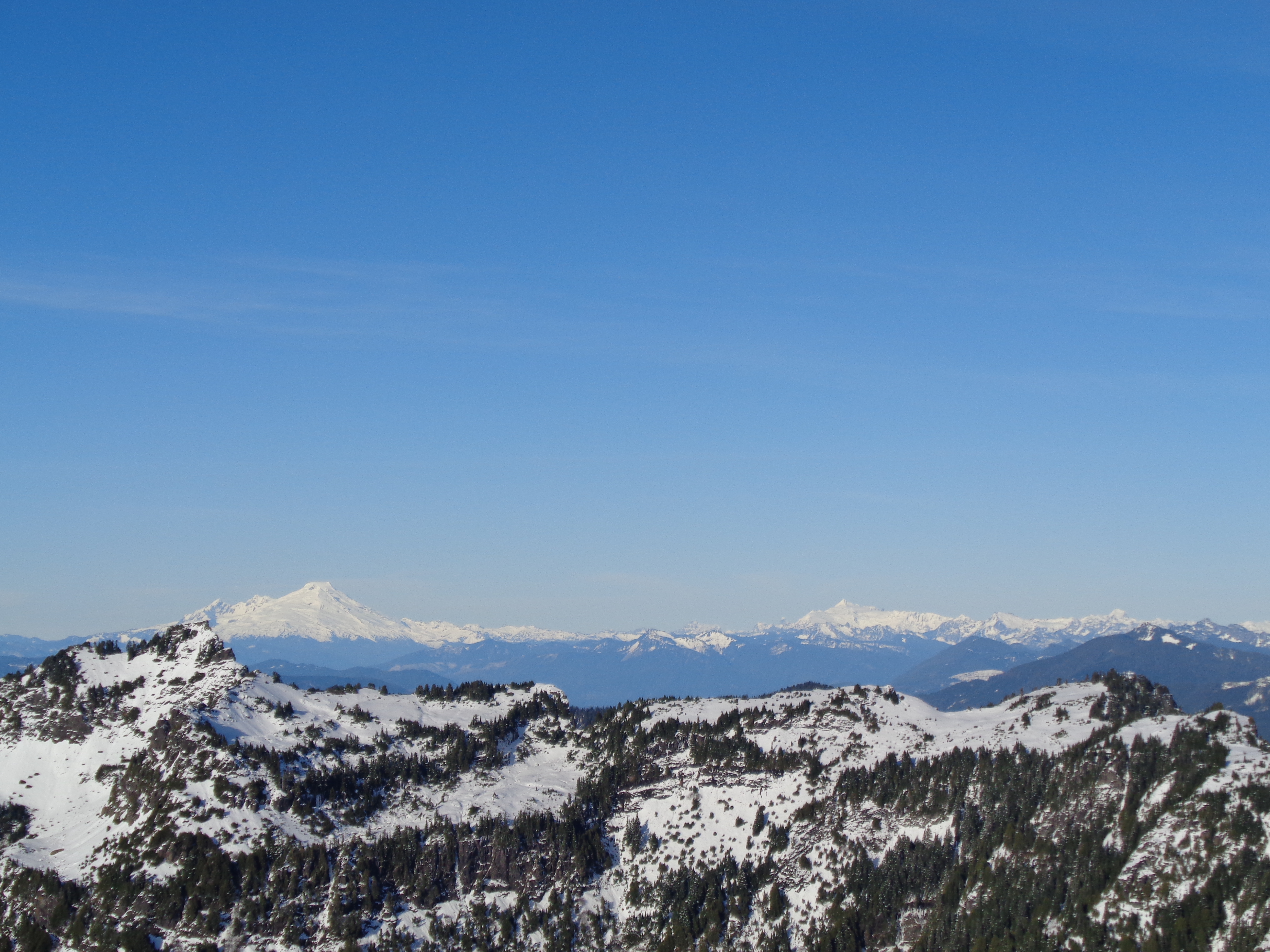
View from the top: Glacier Peak and Sloan
- Distance: 8.2 miles round trip
- Elevation: 3950ft gain, 5760ft highest point
- Weather: high 30’s/low 40’s and sunny
- Commute from Seattle: Just under two hours
- Did I Trip: I slid a bit and landed on my ass but no faceplants
So like I mentioned, it was the last day of truly sunny weather predicted for the next week or so, and I couldn’t pass that up. The trailhead is right off the road, so I knew if the road was clear I’d have no worried about ice. So I packed my hiking bag with some bars, caffeinated gu, aspirin (I was still quite sore) and headed out. I had a feeling this would be a tough hike. Marathon Sunday, struggle hike Monday, 9 hours on my feet at work Tuesday, and then this. So I prepared for it. But I didn’t realize just how tired I was.

Fallen trees criss-crossing over the trail
Averaging almost 1000ft/mile, it was already a steep hike. Getting there wasn’t an issue at all, and I knew I was tired, but figured I could take it slow and I’d be fine. The first two or so miles are just through woods. Steep switchbacks through woods. Really just a mind-numbing number of switchbacks. So I spaced out and plugged along, taking occasional water breaks (I was using my REI pack instead of my camelback – the trail running hydration pack has been retired for the season now that I need to carry more). I was disappointed to see that that there was no light dusting of snow like at Snow Lake. The trial to Dickerman is on the southern side of the mountain, and the light snow had melted. A couple icy stretches along the path, but nothing too tricky.

Trail finally flattens out
After a solid hour and a half of switchbacks, I finally broke into a flat area, maybe the meadow that the trip description talks about. I have no idea, because it was covered in 18 inches of snow. Woo! That’s the great thing about Seattle. Winter is optional. If you want it, you can go find it in the mountains.

Boot path next to icy stream
There was a well packed boot path next to a frozen river, and on the way up, I took the boot path. Microspikes were in my pack, and I could not be bothered to get them out. At this point, I was still only getting sneak-peeks of views across rt 2, and nothing more. But I knew I was getting closer with every step.

Looking up at the peak
At one point, I looked ahead of the trail to an opening where you could see Dickerman’s peak. Shit, I shouldn’t have looked. I was still at least a mile away. Past the meadow, the slope opened up. Still relatively flat, but soon you came to the base of the steepest section. I’m sure in the summer there’s a trail to follow, but in shoulder season, it was “pick your favorite set of tracks and follow those.” I wasn’t about to blaze my own, since the top foot-and-a-half of snow was pretty loose and annoying to trudge through.

Dog across the flats looking down a steep slope we just hiked
As I was stepping up someone’s well-packed tracks, which were basically stairs, a dog caught up to me and bounded ahead. Her owner called her once I had reached the top of the first steep slope, and she ran back to wait for him. I couldn’t resist taking a picture across the flat meadow. She looked like she was built for snow, and was thrilled to be out there. She was having a much easier time of this than I was. I was starting to realize that I was tired. Who would have guessed? My legs were not up to a one-foot-gain-for-every-two-feet-traveled climb.
Baker on the left, Shuksan on the right
Finally made it to the top. With some encouragement from the dog who stood ahead of me mocking my slow progress. I sat on the lower of two peaks since there was a couple on the high one, and drank in the views. At first, I was so tired I couldn’t appreciate any of it. I knew it was beautiful, but I just wasn’t into it. I looked at the first peak in front of me and thought “Oh, Glacier, I thought it’d be closer…” before I turned to the right and saw the real Glacier Peak, smack in front of me. I had been looking at Mt Baker.

Three Fingers on the left, others I can’t recall
So Baker, Shuksan, Glacier, Sloan, Forgotten, Three Fingers.. guys, I’m getting better at the peaks! Slowly but surely. I threw on my extra layers, took a bunch of pictures, had some snacks. Like Espresso gu. I’m not used to stopping at the top for long, especially when I’m alone. But I must have spent 20 minutes up there. 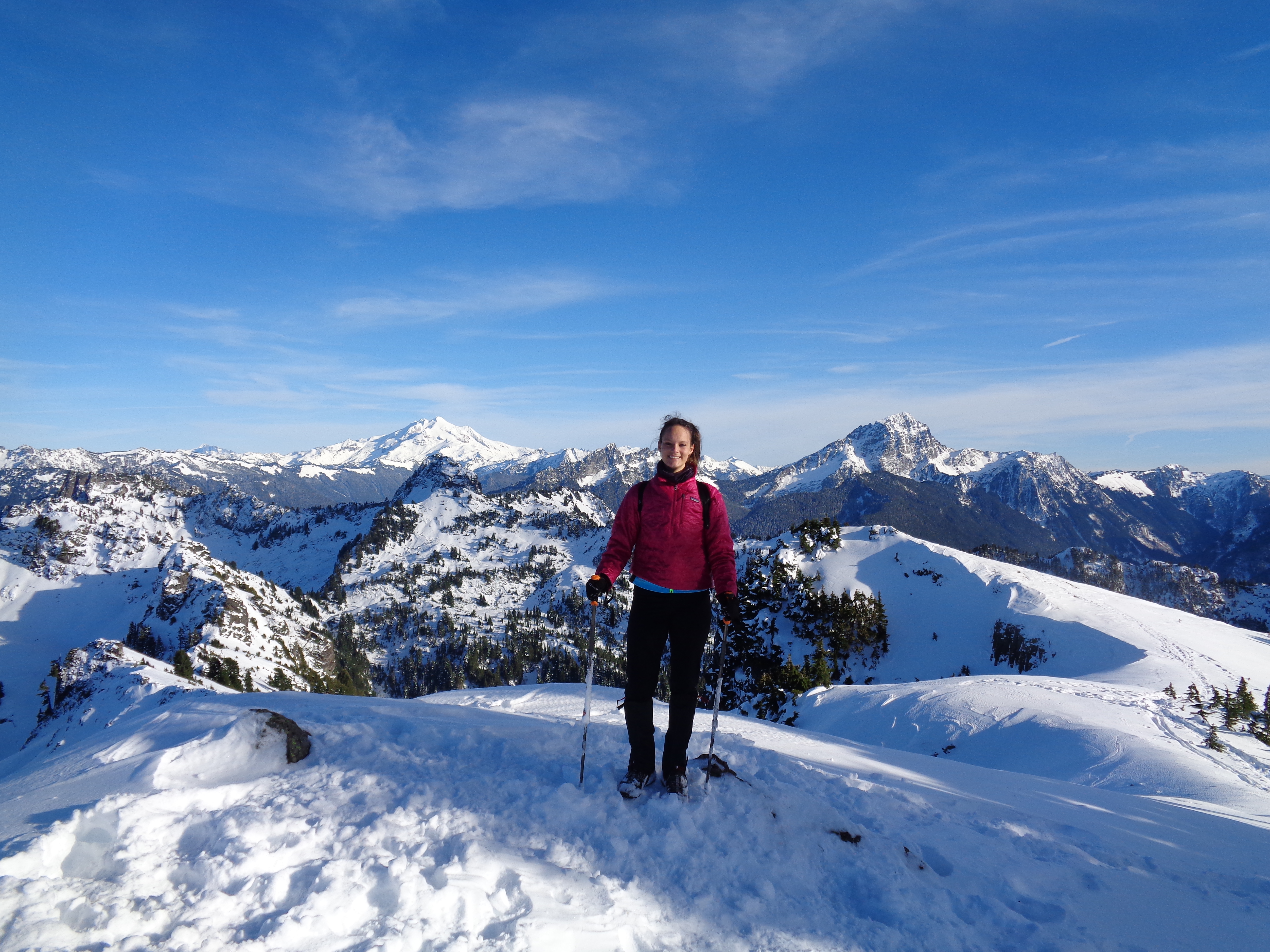 After a while I headed over to the higher peak to have someone snap a picture of me before I headed back down.
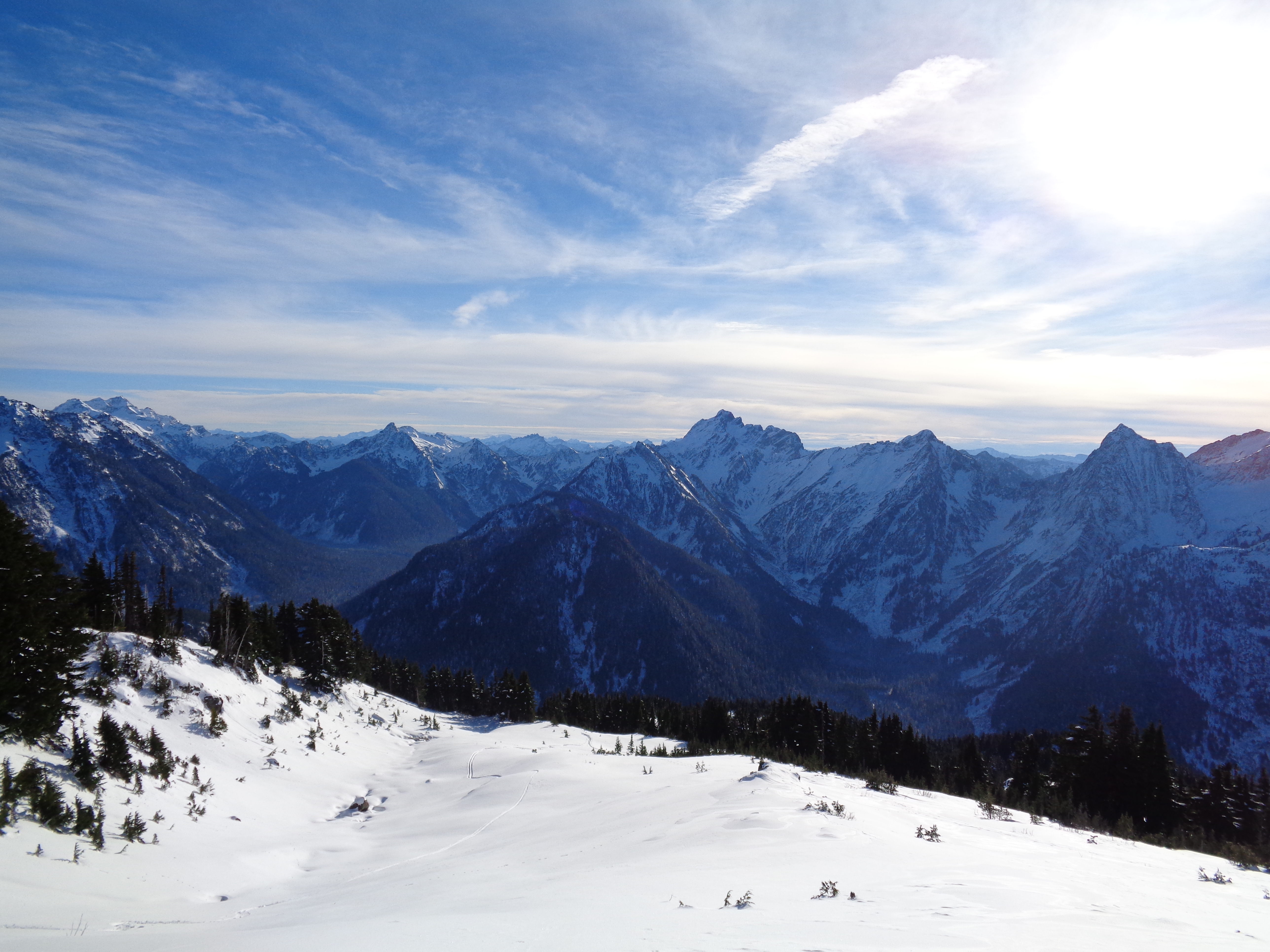
View to the south with ski tracks on the left
The way down was brutal. I put on microspikes to help with traction, since at this point I was tired and getting clumsy. There were some ski tracks along the slopes, and some spots were it looked like someone had glissaded, but putting on goretex pants just to slide 20ft didn’t seem worth it.
I stopped to chat with some happy hikers on the way up, though at this point i was already mid afternoon and light would be fading fast. I have to wonder if they made it or not. It’s a great hike, but honestly, I don’t think it’s a halfway-hike. If you can’t make it to the views, just going up switchbacks in the woods wouldn’t be worth it to me. But I’m a view finder.
Crooked 10-second-timer selfie looking south
I did manage to get what could have been a great 10-second-timer selfie if the horizon hadn’t been so damn crooked. Walking down this stretch was just so gorgeous I had to try to capture it. Wispy clouds, sunshine, mountains in the background.. I thought I hated winter. But winter in a place like this? I look at these pictures and I just think guys, I freaking live here. I can just DO this! I can just drive for 90 minutes and be somewhere this incredible. At the top, I met a girl from Minnesota (I mentioned I went to school in the midwest), and someone asked the two of us if we’d every move back to the midwest – we looked at each other, back at Glacier Peak, laughed, and said “how could you move away from something like this?!”

Trail along a ridge through some trees
Once I broke back into the trees, I remembered the lovely number of switchbacks I’d have on the way down. Crap. I should have counted. Ugh. There were some pretty stretches before the forest got dense, and I did snap a picture of some neat ice crystals. Taken with the “food” setting on my camera, because it was the only one that would focus on close objects.  Once I hit the forest, I kept my eye out for the two criss-crossing trees I had passed earlier, knowing they marked about 20 minutes from the parking lot. IT TOOK FOREVER. My feet hurt, my hamstrings were tight, my left ankle bone kept slamming against the side of my boot (which had never happened before – maybe I was walking weirdly because of the marathon soreness) and I was wiped. The marathon had caught up to me. Used to having boundless energy, I wasn’t sure what to do with myself. More gu. Okay, carry on.

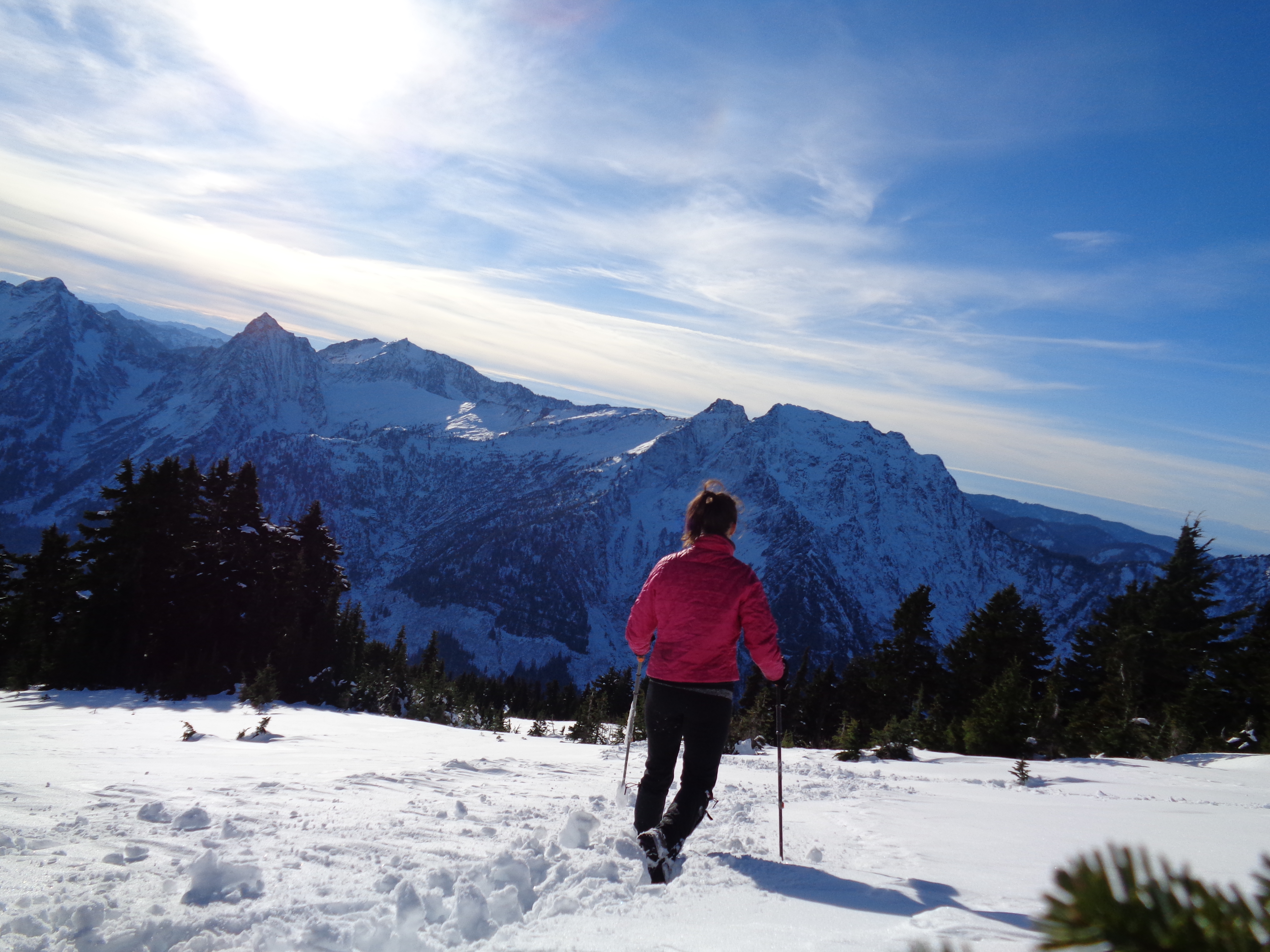
Southeast view from a knoll maybe half a mile from the top
The sun slipped behind the mountain to the south around 3:30, and it suddenly felt like twilight. Funny to think that the hikers 2000ft above me were still in the sun. I finally got to the criss-crossing trees, and then caught a glimpse of rt 2. Yay! So close! I basically ran the last 400 meters or so and collapsed in my car. Thank you, car. I took off my hiking boots and gaiters and put on my goretex Wildhorses to spare my left foot and right ankle any more pain. Thank god I left those in my trunk. Jeez. It hurt to use the clutch, but whatever, gotta get home. Oh, and the “check engine” light had come on. I was a mess. The drive home was uneventful, and I spent the next few days hobbling around on a bum ankle and a bum foot. Time to invest in different boots.
It’s funny, because uploading the photos, I was floored by how amazing everything was. Which, like I said, I knew when I was up there. It was just hard to appreciate at the time when my brain was foggy with soreness and exhaustion. It was like coming down from Rainier, knowing I was on a massive mountain in one of the most beautiful places, yet too preoccupied with wanting to rest to truly appreciate where I was. I had some moments of clarity on Dickerman, but I’d love to go back fresh. I’m sure I’ll be back in summer. I bet the slopes and meadow get some great wildflowers. Overall, incredible hike if you can tolerate the beginning switchbacks. Bring a chatty friend!

That panorama from the top is EPIC! Jealous. And it looks like you should be able to keep getting out there this “winter.” At least for a little while longer.
LikeLike
“The great thing about Seatle is that winter is optional.” I like that quote. It’s 2 degrees in Boston right now. Not optional.
LikeLike
Pingback: Mt. Pilchuck | Have Tent, Will Travel
Pingback: Spring Training | Have Tent, Will Travel