

Dock Butte Snowsho-ooot I wish I was on skis. Let’s get some q’s out of the way first. Yes, I wore snowshoes. Yes, they’re still torture devices. No, I have no pride or shame or whatever you’re thinking, I’m not above any mode of transportation that gets me to mountains. I think they get you in better shape than skis too (assuming both are on your feet). Yes, there’s a couple hundred feet of great skiing up there with PRIME photo opportunities. No, I haven’t quit skiing. Right, I’m not sure it’s worth bringing skis up through that bushwhack, but if you have a snowmobile, DEFINITELY snowmobile the road and bring skis. Ok. Moving on.
- Distance: ~10mi round trip
- Elevation: 4,000ft gain (5,239ft highest point)
- Weather: 30’s and sunny
- Commute from Seattle: 1:50(!)
- Did I Trip: Plenty of blown out snowshoe steps but no true trips
- Roughly followed this gpx track
We met at the park n ride at 6, a welcome change from the 5am meetups Tim has apparently been scheduling. We were a group of four: Tim (the gecko from a few prior trips), Andrew (just meeting him for the first time) who is an encyclopedia of obscure Cascades knowledge, and Charles, with whom I actually climbed Rainier 6 years ago but hadn’t seen since! I recognized him but couldn’t tell from where, until half an hour later in the car I mentioned climbing Rainier with Rob and Charles goes “I know, I was there!” Ha! That’s where I knew him from!

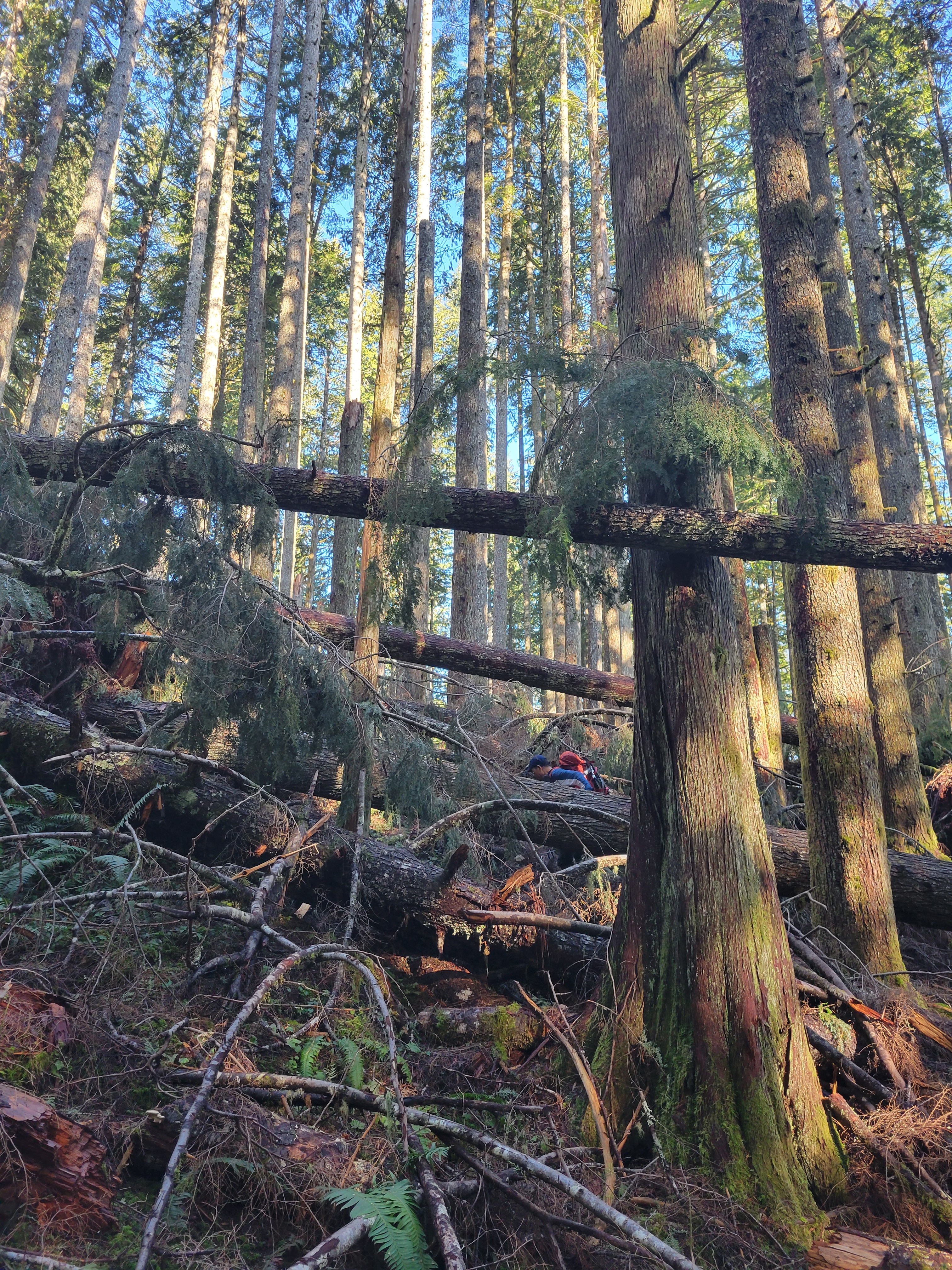
We started from the “trailhead” around 8am. The trailhead was just an unmarked pull out off Baker Lake Road where an abandoned road started. We hiked an abandoned road for a bit before cutting straight up through the forest. The bottom ~1000ft of gain were BRUTAL. Tons of pick-up-stick style downed trees you’re going up and over and under and around, head-height new (teenage?) saplings stuffing pine needles down your shirt ready to slap you in the face when you’re too close to the person in front of you, and a whole lot of “marco?!” “POLO!” to find each other. I swear 60ft to our left looked pleasant and open. I was convinced we were just slightly off route trudging through unnecessary brush, because no prior write ups had mentioned brush this thick. You know it’s bad when no one’s taking photos. There’s a sweet spot where it’s bad and it’s funny so you get some pictures, there a point where it’s open and beautiful and you get pictures, and then there’s head-down-plow-through-NOTHING-ELSE-MATTERS and this… this was the latter.

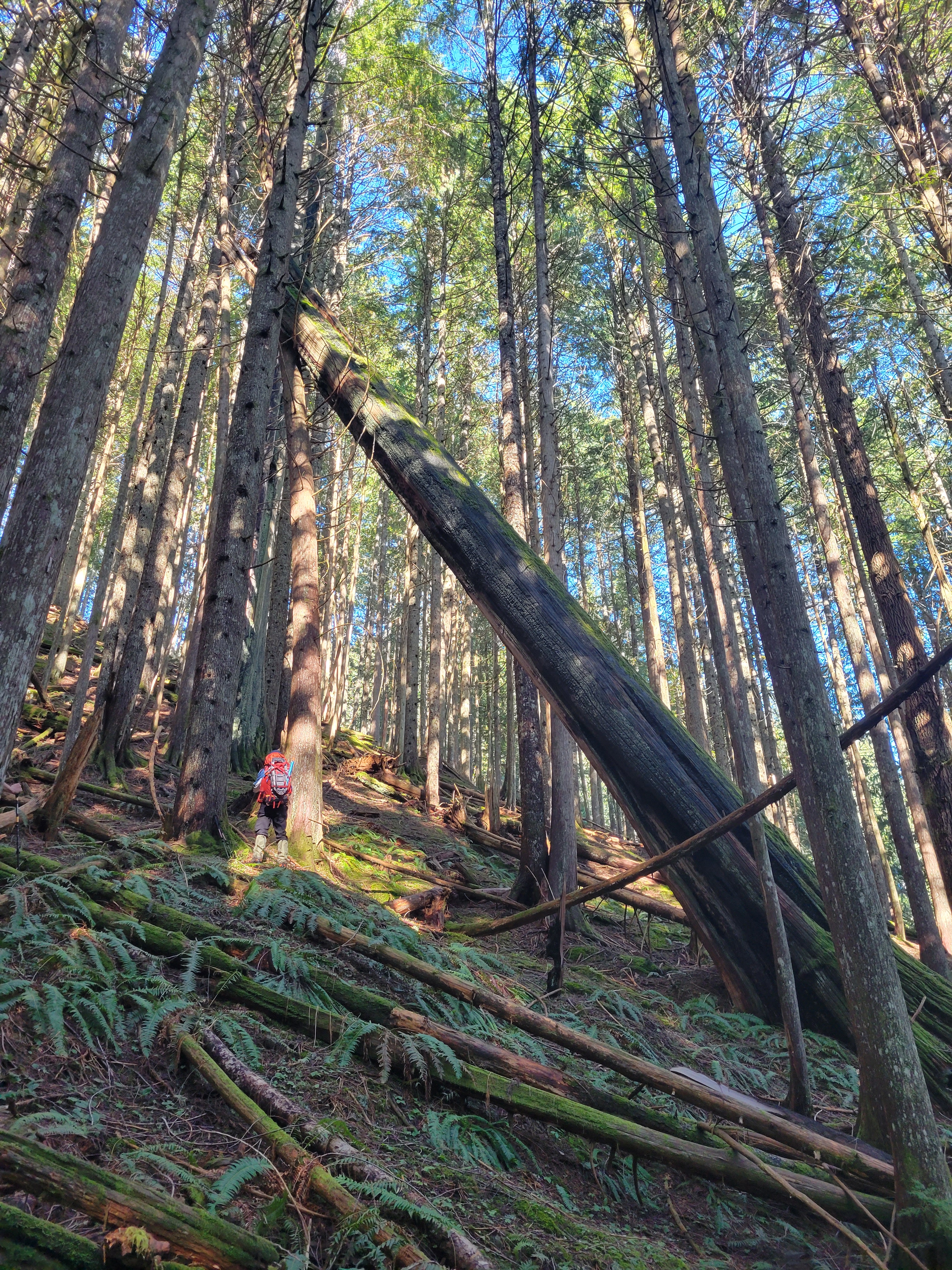
We finally escaped the brush and entered old growth. I looked behind us and couldn’t see Andrew, but I could see bushes and small treetops rustling, so he was under there somewhere. Charles pulled up beside me. “Oof. That was pretty bad.” I laughed. “Heinous.” “My route was even worse… he’s never going to follow me again.” Andrew burst out from the brush and glared at Charles. “I’M NEVER FOLLOWING YOU AGAIN!” I burst out laughing. Tim, as usual, was somewhere ahead of us hurdling downed trees and vaulting stumps and dodging brush, because as geckos usually do, you blink and they are gone. We heard him whoop and headed towards his voice. Finally. Finally we could walk without incident. At least for a few minutes. Andrew and I were going back and forth about lesser known peaks in the Cascades, and I couldn’t remember one that Brad and I “skiied” back in December or January. It wasn’t Philadelphia Mountain. It’s like Philadelphia, but there are views at the top. I swear it’s so similar to Philadelphia. It’s on highway 2. West of the pass but east of like.. Sultan. East of Baring. Andrew’s spitting out peak names. “This is going to drive me crazy.” “I’ll look it up when we’re back to the car I promise.” “Merchant.” “no…” “townsend?” “no, south of the highway” “lennox” “no but we took our skis for a walk around that one too” “Cleveland?!” Yes!! I laughed. Brains are weird. The connection to Philadelphia was probably “peak with a city name,” not “random peaks along highway 2.”

We crossed a large plateau with an unfortunate stretch of more downed trees that still had some snow for prime posthole effect, and then started the real elevation gain, thankfully in open forest for real this time. We took a short snack break where I cut a shot block into 4 pieces (this endeavor was even stickier than you’d expect) and gulped it with water like sugar pills because that’s how you fuel with Invisalign. As someone in a perpetual state of dehydration, maybe this will be good for my overall performance, who knows. I only had one liter of water, so needed to be conservative about that. I tied my buff to my pack strap to wipe sweat off my face as we hiked.
We continued gaining elevation until we broke out onto a very obvious groomed road. We followed the road to the normal trailhead, which isn’t accessible anymore in summer either thanks to a massive road washout in summer 2020. That’s a big bummer, because this hike is only 4.5mi round trip, starts high, and is (well, was) extremely accessible with totally wild views. Tough seeing a hike with such potential suddenly be nearly inaccessible. At the true trailhead, we put on snowshoes and started off on the summer trail towards Dock Butte.
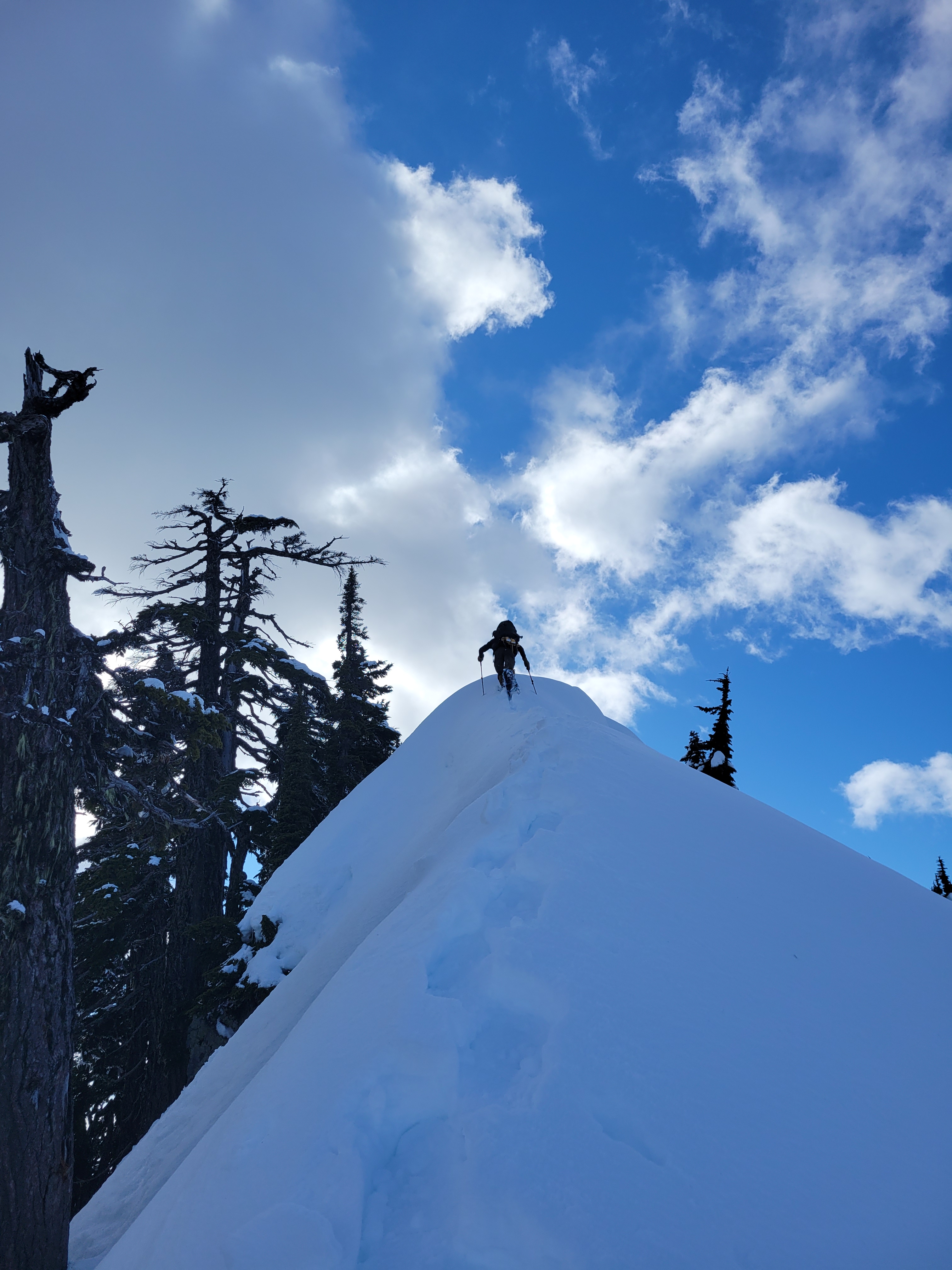
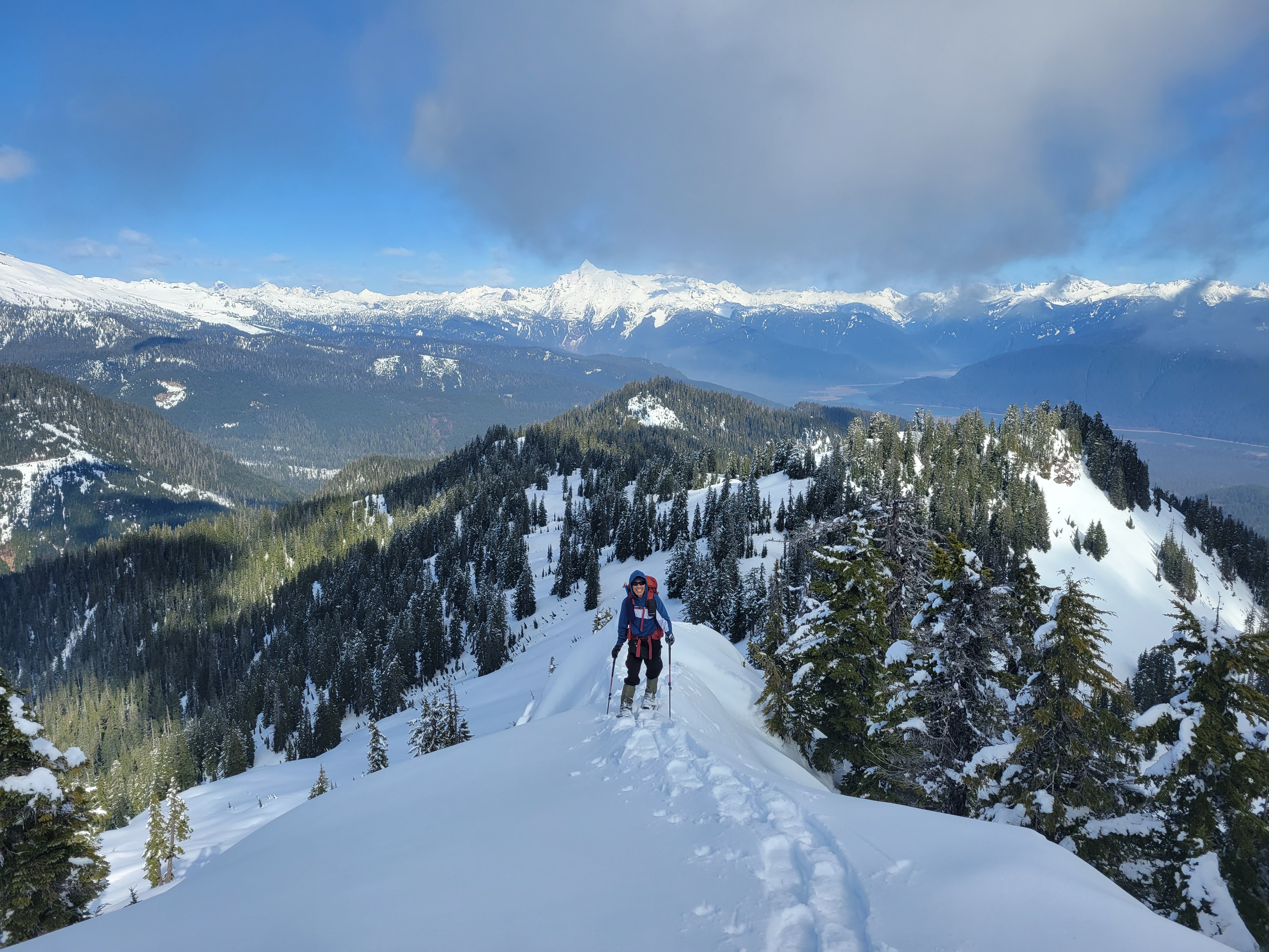
We left the summer trail after about half a mile to gain the ridge that would eventually lead us to the top. It’s a rolling ridge with plenty of ups and downs and peekaboo views of Baker and Shuksan that become more and more glorious as you get above the trees. This entire hillside would be a phenomenal place to camp in the winter if you want to lug gear up there (orrr rent a snowmobile). Once the Twin Sisters range (and Dock Butte itself) came into view, the sidehilling started as we dropped off the initial ridge to skirt a knoll and gain the final ridge to Dock Butte. It looked intimidating from below. Steep, almost knifey, we were in snowshoes, and the contrast of sun vs shade made it all the more dramatic. I turned to Tim. “This is where Rob would start singing the final countdown” and just like that I had a new, more annoying song stuck in m head even though Rob wasn’t actually around to be the human juke box as usual.
Andrew led the way up the ridge blazing a snowshoe trail and the rest of us followed. I was not worried about falling north off the ridge because the runout was nice enough, but falling south… I don’t think you’d even have a chance to self-arrest before tumbling a long ways unless one of the trees caught you. Especially in clumsy snowshoes, I was not stoked on the way down. Going up for me is always easier than back down. I heard Charles shout something to Tim. “I’m tired is what’s going on!” Charles basically woke up one day a few weeks ago and decided to bushwhack 4000ft in elevation with snowshoes. Yeah no shit, I’m tired and I’m funemployed and getting out routinely! Tim met us at the top followed by Charles (success!!) minutes later.
Clouds moved in as soon as we reached the top (of course) and we spent some time snacking, chatting, napping, and waiting for pesky clouds to move. The Twin Sisters range looks SO WILD from here. I couldn’t wait to send Brad and Surafel a pic asking them to guess the peak because I know I wouldn’t recognize them. I feasted on gummy worms and a chocolate rice krispie (better than expected) and the rest of the shot blocks. I realized my buff had gone MIA at some point earlier in the day. After probably an hour with clouds getting closer and closer we finally started to get a bit cold, and packed up our gear ready to head down. Twin Sisters were holding back the clouds, as we dropped lowed it appeared Dock Butte itself was holding back the clouds, and soon enough.. it was just kind of cloudy.

You always think on the way down you’ll find the right trail/route and it’ll be smoother than life on the way up. Unfortunately, that wasn’t the case today. Getting back to the road was easy (didn’t find my buff), then a pleasant road walk (still didn’t find my buff), then we headed straight down doing our best to follow our own footprints (not finding my buff, RIP). We cruised back to that original plateau where we hit postholey snow, downed trees, and brush all over again. Guys, I suck at log walks. Suck at them. I know you don’t just randomly forget how to walk in a straight line but something about them freaks me out, and we had a LOT of log walks to try and avoid the brush. Downed trees can be like highways 4-5t above the brush if you can string enough together. Or you can swim besides them through brush because you know that given 20 log walks, you will fall off of one, and it would definitely be this one. Or that one. Or that other one.
The plateau was bad, but I knew from there back to the car would be worse. I was hoping we’d find a better route having line of sight/currently on a path of least resistance to our advantage, but no. We ended up climber’s left/skiier’s right of our uphill route, in the area I had thought would be more open earlier that day. Well, I was wrong. Extremely wrong. The downed trees never stopped. They might have been even worse than on the way up. The brush didn’t let up. Our progress slowed to like 0.5mph. Are we even making progress? I stopped to grab water and found that I had, in fact, been carrying 3L of water the whole time, not 1L. That’s what you get for never fully unpacking your pack in a few days.

We finally came across the remains of an old road not even marked on my map, and followed that for as long as we could. I think we could have followed it all the way back to the “trailhead” to be honest, but we started to cut straight downhill again to be safe, eventually landing on flat ground STILL covered by criss-crossed dead trees and thick brush except this time with the bonus of a swamp too. Tim led the way over and under and around fallen trees and bog pits “it’s like 80ft this way” [400ft and 15min of suffering later] “that was not 80ft” “yeah i definitely misread something back there” until we finally popped back onto the old road we had started on. The road that had been mildly annoying that morning, but was a total relief that afternoon.

Back at the car I was still talking about how great the views had been and how much I love sneakers and sitting. What a pleasant surprise. Dock Butte wasn’t even on my radar until Tim mentioned it, and the trip reports I found from winter were generally socked in by weather so hard to gauge what it would actually look like. But looking at the position on a map and the prominence (it’s #100 by prominence in Washington with 2,309ft of prominence) I figured it HAD to have good views as long as you weren’t in trees the whole time. And I do love an “abandoned hike” This isn’t really abandoned just yet, it hasn’t even been two years since the road washed out, but who knows, maybe in 30yrs it’ll all be totally overgrown and unheard of. Or maybe the forest will self-thin all the saplings that are currently 5-10ft tall and the first 1000ft of bushwhacking won’t be as soul sucking as it was. I’ll get back to you in a few decades. Either way, great workout both physically and mentally and every time I wanted to bitch I just thought how nice it was to not be carrying skis.
Oh, and when I got home to get in the shower? I dropped a small forest all over the floor thanks to all the sticks and needles in my hair or stuck to my neck or down my shirt. That’s how you know it was a good day.

slava ukraini, geroyam slava!
LikeLike