
Looking up the ridge at a bump along the ridge to Alta
Getting up is optional, getting down is mandatory. That’s a phrase I try to live by on solo hikes. Yes, most of the time if I get up, I can get down, but I try to take everything into consideration. How tired will I be if I get to the top? Will conditions change? Will it take me just as long to downclimb this, or can I glissade and get back more quickly? If I’m tired at the top, will this be dangerous to climb back down? This ended up being a bit of a motto for this hike. Hiked 4/30/2015.
In addition, I don’t know what to do with all of these hours of daylight. The sun is already setting later than anywhere I have ever lived, and when I’m out hiking, I have this inherent need to take up every hour of sunshine and I’m finding that harder and harder to do! This means I will either need to a) take more breaks b) take longer breaks c) get more in shape and go farther. I like the last option, because with this ambitious hike, it was potential tiredness that made me head back earlier than necessary. But, I got way more done than I expected, which is pretty neat. And some great recon for the area that so many people have been asking about over the past week or two.

The west side of Alta’s ridge, viewed from Rampart Lakes. I made it to the point on the far right, true summit is on the left.
- Distance: 11.3 miles (Rachel Lake trail up to Rampart Ridge, halfway up Alta, back to the edge of Rampart Lakes)
- Elevation: 3508ft gain, 5900 highest point (Alta’s true summit is just over 6100)
- Weather: 60’s and sunny
- Commute from Seattle: 1:30 (4 hours on the way back since a few cars thought it would be a good idea to crash on the i90 bridge and trap everyone)
- Did I Trip: I slipped in mud once. I got complacent on the way down from Rachel Lake since the hard part was over.

Sunlight caught in a waterfall

View from a meadow
We’ll start with Rachel Lake. I expected snow on the road because of the last few trip reports, but it was just about all melted by the time I got there, and the patch that remained could be skirted. I parked at the huge, empty trailhead (smirking to myself, last time I was here I was well on my way to being very late for work so I got butt naked and changed right there in the parking lot) and hit the trail.

Mossy creek bed
I actually forgot how beautiful this trail is. It alternates between forests, fields with views of Hibox (and pussywillows! I never thought about where they grow wild), waterfalls, and mossy creek beds. Even if you’re just going to Rachel Lake, it’s a gorgeous trip. The trail is flat for a little more than 2.5 miles, and then starts to gain elevation pretty quickly just past where the boot path to Hibox leads away from the trail.

The best game: where’s the trail? (answer in text)
The trail becomes very rocky and rooted, and doesn’t always look like a trail. It’s always there, you just need to keep an eye out for it and pay attention to switchbacks. That pic to the right has the trail on the right hand side, up and over all of those roots just past the rocks. Sneaky switchback, really. Back in October, a little birdy told me the way at one point. It landed on a branch and chirped and flew off down the trail when I was confused. Thanks, little guy! This time around, I was more familiar with the area.
The trail was mostly snow free besides a few patches until about a quarter mile from the lake. When you see the “campfires not permitted at Rachel Lake” sign (something like that) you’re close, and that’s where the trail disappears into snow. Right now, there are footprints in most of the snow to follow. You’re slightly east of the lake at this point, so head straight west and you’ll hit it.

Rachel Lake
The lake is starting to melt out, which will be gorgeous if the snow lingers a little longer because it’s a very light blue lake. There are a few areas to camp, though much of it is still covered in snow. To gain the ridge, head to the right around the north side of the lake. In the summer, there is a bootpath to follow, but this time of year, choose your own adventure.

Looking down on Rachel Lake from Snack Rock
There were some old prints that I stuck with until the ridge, where they headed up some steep snow and I chose to aim for the closest rocky area and scramble up to the ridge instead. I had postholed thigh deep – the snow caught me, my foot was just dangling in thin air, and figured I’d rather take my chances on rocks instead of snow.
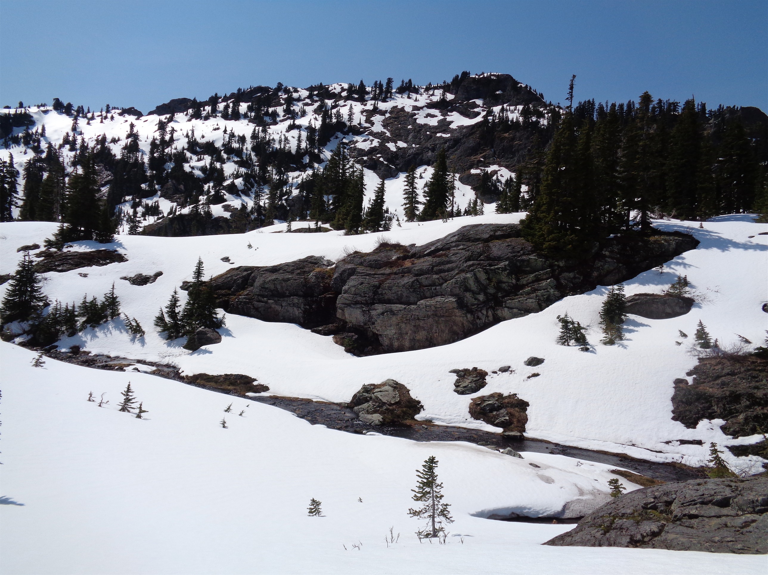
It was a short scramble to the ridge, and I popped up next to an outcropping of rock that became my base camp of sorts. I dubbed it “Snack Rock.” It looked out over the whole valley with Rachel Lake to the right, so I set up and had my first snack break. I was planning on Rampart Lakes, but I was so damn close to Alta and it wasn’t even noon yet, so I couldn’t resist checking it out. After my run there last fall, I have a thing for Alta Mountain. Off I went.

Looking back at my footsteps on the way back from Alta
There were a few footprints to follow along the ridge at first, winding through trees along the flat section. I followed them up the first knoll, crossing snow fields and bare rocky patches. After about a half mile from Snack Rock, the footprints disappeared. I saw some heading to Lila Lake down below, so perhaps that’s where they went. I carried on along the ridge. I swapped poles for ice axe when the ridge became narrow and the drop off became steep. Snow conditions were still good at this point, even my steps weren’t triggering pinwheels. But it was warm and the sun was shining directly on the slopes, and I knew it wouldn’t last. I didn’t stop to take photos in any of these areas. Quick, focused moving was key.

Lila Lake and Alta tarns down below
Looking ahead of me, I saw what I thought was the summit of Alta. Could it be?! Heavily corniced, it already looked sketchy, but I saw a scramble route along the dry west side of the ridge that I could take. The cornice I was looking at was bigger than me, looming over the east side of the ridge, looking down on a steep avalanche slope. I have no idea how I forgot to get a picture. No chance I was crossing that. Getting up to the dry side of the peak, I saw that I was still about a mile from Alta’s true summit. Maybe with some friends and a huge pair of balls I could have scrambled along the dry side to get around the cornice and carry along down the ridge.

The “nice side” of the ridge. Cornice is on the right out of frame.
Or with friends, balls, and an alpine start, the snow slopes would have been fair game. But the snow was softening quickly, steeper slopes had snow sloughing already and my steps were starting to trigger pinwheels. Nope, not soloing any of that. I was anxious enough to get back across the avalanche slopes I had crossed just to get here. Okay, I’m out. I turned around and headed back along the ridge.

Rainier
The ridge is still stunning. Covered in snow, Rainier looming behind Rampart Lakes in the distance, and god dammit I realized you could see i90. I hate seeing highways. I blocked it from my mind and focused on the peaks in the other 320 degrees around me. And oh, Rampart Lakes! I finally knew where they were. I had assumed they were on the other side of the high peaks of the ridge, but they were just beneath them on the northwest side. Perfect. Descending to Snack Rock went quickly, and I stopped there to take a second break and debate returning, or going to Rampart Lakes.

Looking back along the ridge from the knoll

Looking out at the northwesternmost Rampart Lakes
For those of you who know me, it’s no surprise I ended up going to Rampart Lakes. Again, I had all day, and was about to start a 12-day streak at work, so I had to get my fill of wilderness. There were no footprints leading over to the lakes, so I blazed trail following the flat ridge until I got to some frozen, snow-covered lakes. There was a river running through the middle that was starting to melt out. I hiked past the first few tarns, and took a break on a rock overlooking the river. It reminded me of Gothic Basin, but with darker rock and more trees.
Small river going through Rampart Lakes
Knowing I had to get down that sleep talus slope was weighing on my mind. I wanted to be feeling physically pretty good when I had to head down, and crossing the river to get to the rest of Rampart Lakes looked more complicated than I wanted to deal with since I could either downclimb a steep snow slope and walk up the other side or walk around until I found a less steep option. I decided to head back. The lakes were all frozen, so I can’t imagine I would have had any groundbreaking discoveries out there. I took a slightly easier route back to Snack Rock (at one point on the way there I was bushwacking through trees and underbrush when snow would have been easier) and took one final break.

An Eve shaped space!
Like I said, getting up is optional. But you can’t avoid getting down. I looked down the slope I had come up, took a deep breath, and started down. Shockingly I didn’t need to crab-walk any of it like I expected. Halfway down, I breathed a sigh of relief realizing it wasn’t nearly as bad as I had made it out to be in my head. No, stop, don’t get complacent! I focused on every step. Finally back on snow, I stepped carefully, wary of my earlier posthole. I skirted that area, but no luck – I postholed chest deep. Okay, that’s not a posthole, that’s just falling into a boulder well. One foot landed on rock, I threw my arms out across the snow, and the other foot dangled in space. I spread my poles across the snow and managed to pull myself out, leaving an Eve-shaped space looking into darkness. Naturally I snapped a pic and continued on my merry way.

Tree over a quiet section of river
I followed my own steps back to the trail. No one else had come up even to the lake, mine were the only fresh prints. It’s too bad, because this is such a beautiful hike, and the lake is pretty accessible right now. Strava map can be found here. As far as gear goes, nothing special needed to get to the lake, maybe a map if you want to play it safe. Up on the ridge, Rampart Lakes was straightforward, but heading over to Alta you’ll want an ice axe. Never touched microspikes or crampons, though if you plan on summitting Alta, you’ll want to make more traditional mountaineering plans.
I will say, this hike is especially gorgeous in fall. As cool as it was yesterday, I couldn’t help but think back to all the fall foliage along the ridge in October. If you aren’t a fan of snow hikes, check it out in the early fall when the leaves are turning. Here’s my blog post from the fall, when I was still crappy at photography and writing. I will say, it’s definitely my favorite trail run so far. How can you walk along that ridge and not want to run it? I have to bring a buddy back there to get running pics next time.

The ridge back in early October

Wonderful report. We tried to go there about a month ago but couldn’t get tot he trail head. We tried hiking in but it was just too long for the amount of time we had. Excited to see its open! Oh and love your blog!
LikeLike
Thanks Melissa! It’s a great trail but it sounds like he road does get snowed in easily, I was surprised to see it was passable at all. I thought I’d be hiking to the trailhead too! Hope you have a chance to get back!
LikeLike
I like the October vs. April ridge photos and the waterfall photo. That chest deep collapse is scary. Be careful.
LikeLike
Thanks for the trip report. I am guiding a trip up that way in June and was looking for conditions. I really appreciate you taking the time to fully report on all the conditions. Here hoping to warmer weather to melt some of those cornices!
LikeLike