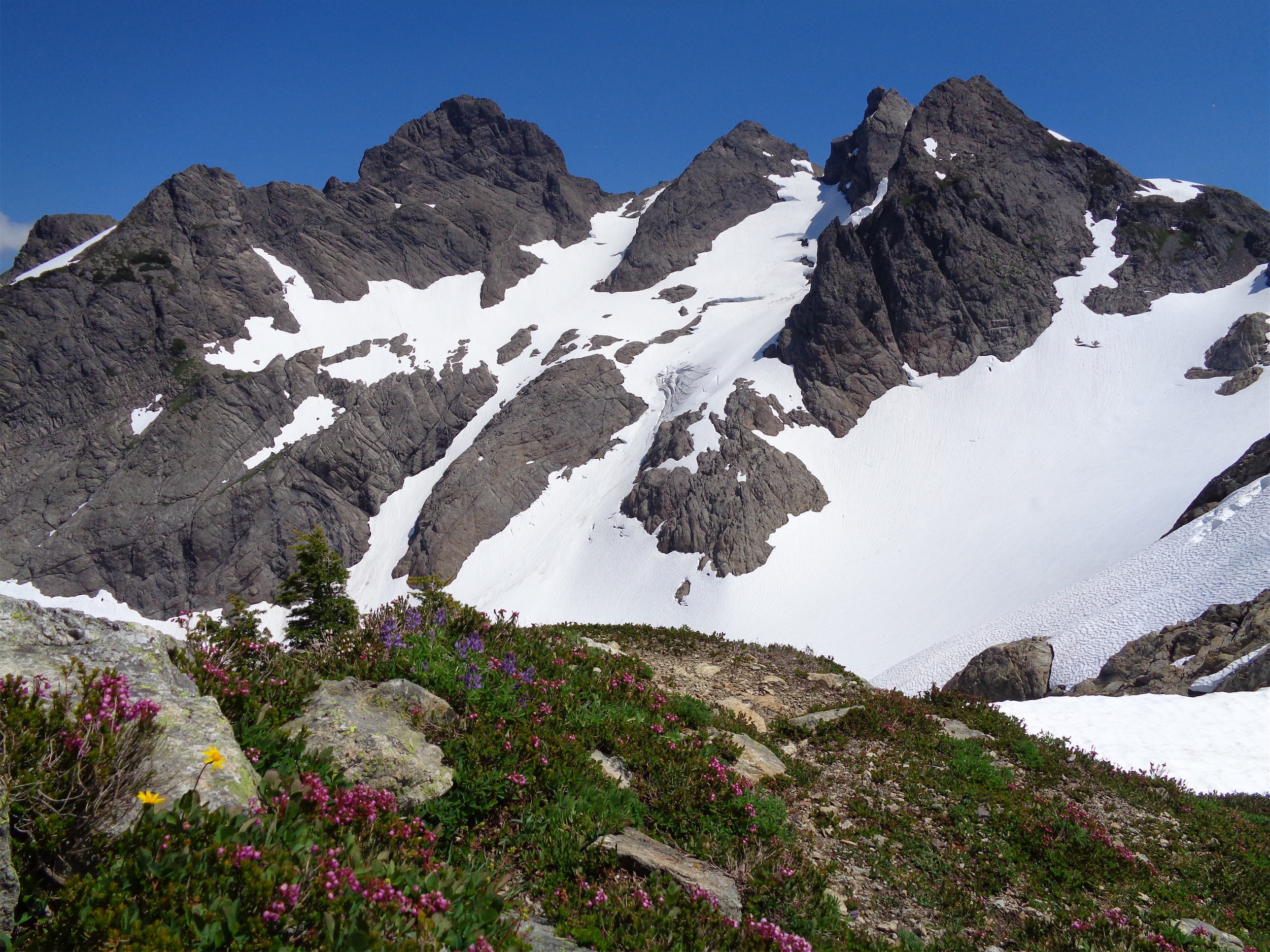
Three Fingers from Tin Can Gap
Well you know Murphy’s law. Anything that can go wrong will go wrong. We came out of it alive, but this was certainly a casual-hike-with-a-bonus-rock-climb-turned-epic-mountaineering-objective due to our unfamiliarity with the route. We improvised where it might have been faster to be normal, and we tried for normal when it might have been faster to improvise. Whoops! I swear not all trips are like that. And it wasn’t a shitshow, just longer than we expected. Hiked 7/15-7/16, here is the Three Fingers Lookout!
- Distance: Roughly 18 miles. 7 up, 11 down.
- Elevation: ~4800ft gain, 6,854ft highest point
- Weather: 50’s and sunny, 40’s and misty
- Commute from Seattle: 2 hours without traffic (but there was traffic)
- Did I trip: Yes, mostly I fell uphill on the damn bushwack in the night

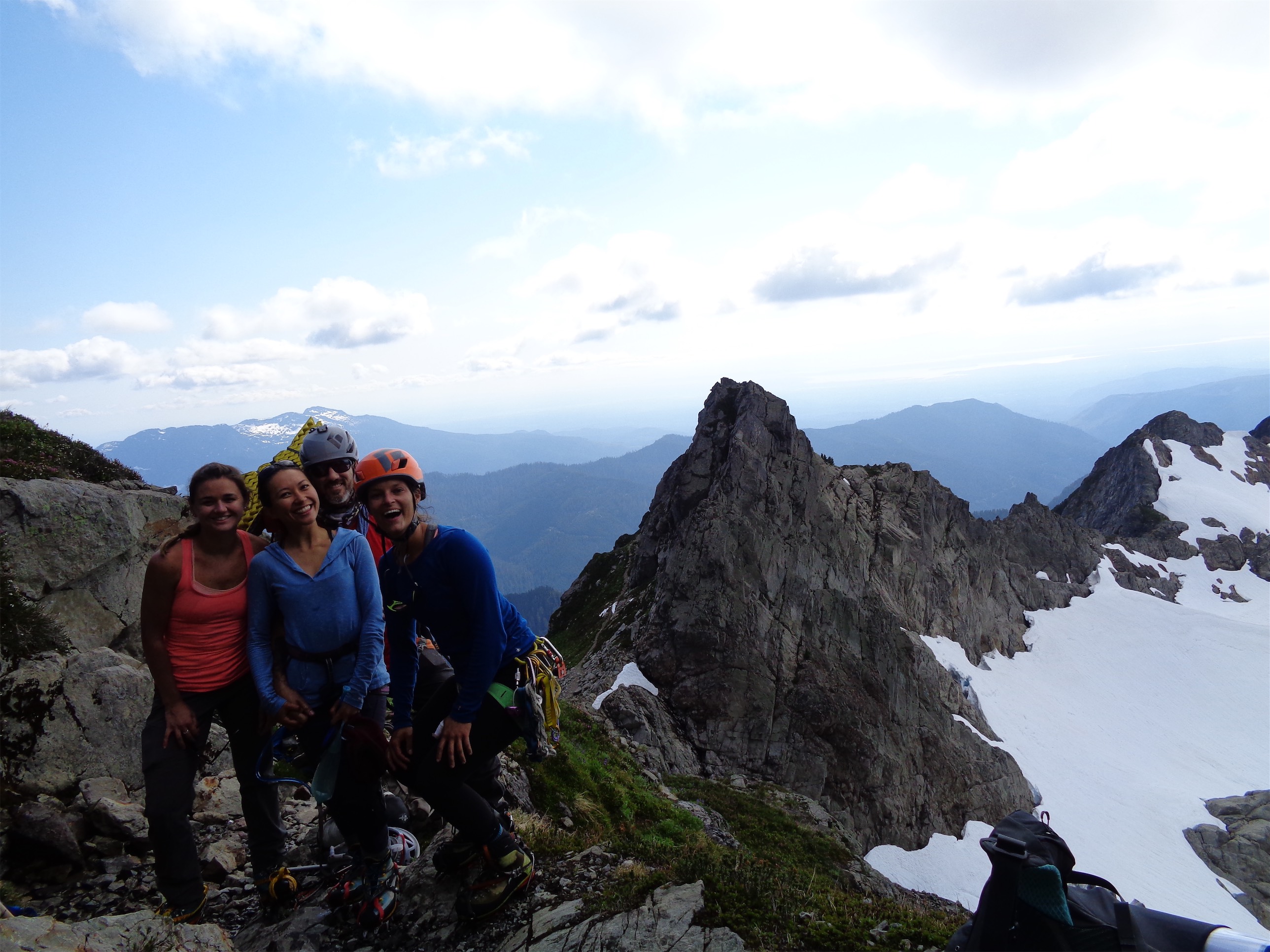
I’m a spooky ghost (selfie credit: Haley)
We started up around 8:30pm on Friday, which was 11:30pm for the visiting Floridian (Haley). She was tan at least, so she had that going for her. Convinced I’d be last to the party, I went straight to the trailhead, where I met Calvin, Tricia, and Florida after getting myself lost on a gated forest road. Nailed it. The road to Three Fingers is truly blocked now, with enormous boulders buried in dirt so no one can tow them off like last summer. They really don’t want people driving down that road. There’s also an enormous cedar tree down across the road maybe a mile past the boulders, and I have no idea what’s past that besides an enormous washout ~2mi from the true trailhead. Probably more terrible things waiting to destroy your car.

Bivvy morning (photo credit: Haley)
We took what we thought would be a shortcut up a ridge pretty much straight from the road closure to Goat Flats. Unfortunately, in the dark, that “shortcut” was more like “a five hour long epic” that didn’t quite get us to the flats because around 2am we decided we were just going to camp at the next flat spot we saw. The shortcut was steep, brushy, had some nice 3rd class scramble moves through the forest, a bleached goat skull (“a human skull?! I’m fucking bailing if it’s a human skull that’s just too creepy I hate the forest”) placed a little too perfectly on a rock, sticky green seeds from bushes that clung to my leggings like velcro, a plethora of spiderwebs, probably bears, and the echoing of gunshots from the rednecks on the forest road below (no offense guys, but between the guns and the thumping base at 1am you aren’t exactly making a great first impression). Haley and I apparently don’t like the dark or bumps in the night, Calvin and Tricia were way behind, and I can’t see shit in the dark, so that left Haley to be the brave one and scout out the flagging tape. We started classifying spiderwebs. Class 1 was a strand of cobweb. Class 2 was a legit cluster. Class 3 was a full formed web. Class 4 was a huge fucking fully formed web with the spider inside of it and I don’t want to know what class 5 would be and 5.12a would probably be enough to send me into cardiac arrest and flee this world for a better one. I had my usual “what are we doing here” moment around 12:30am when Haley took a bathroom break and I stood in the dark waiting for Calvin and Tricia. Why do we do this? Haley had hers an hour later when she bitched out a pinecone. You show that pinecone who’s boss, Florida.
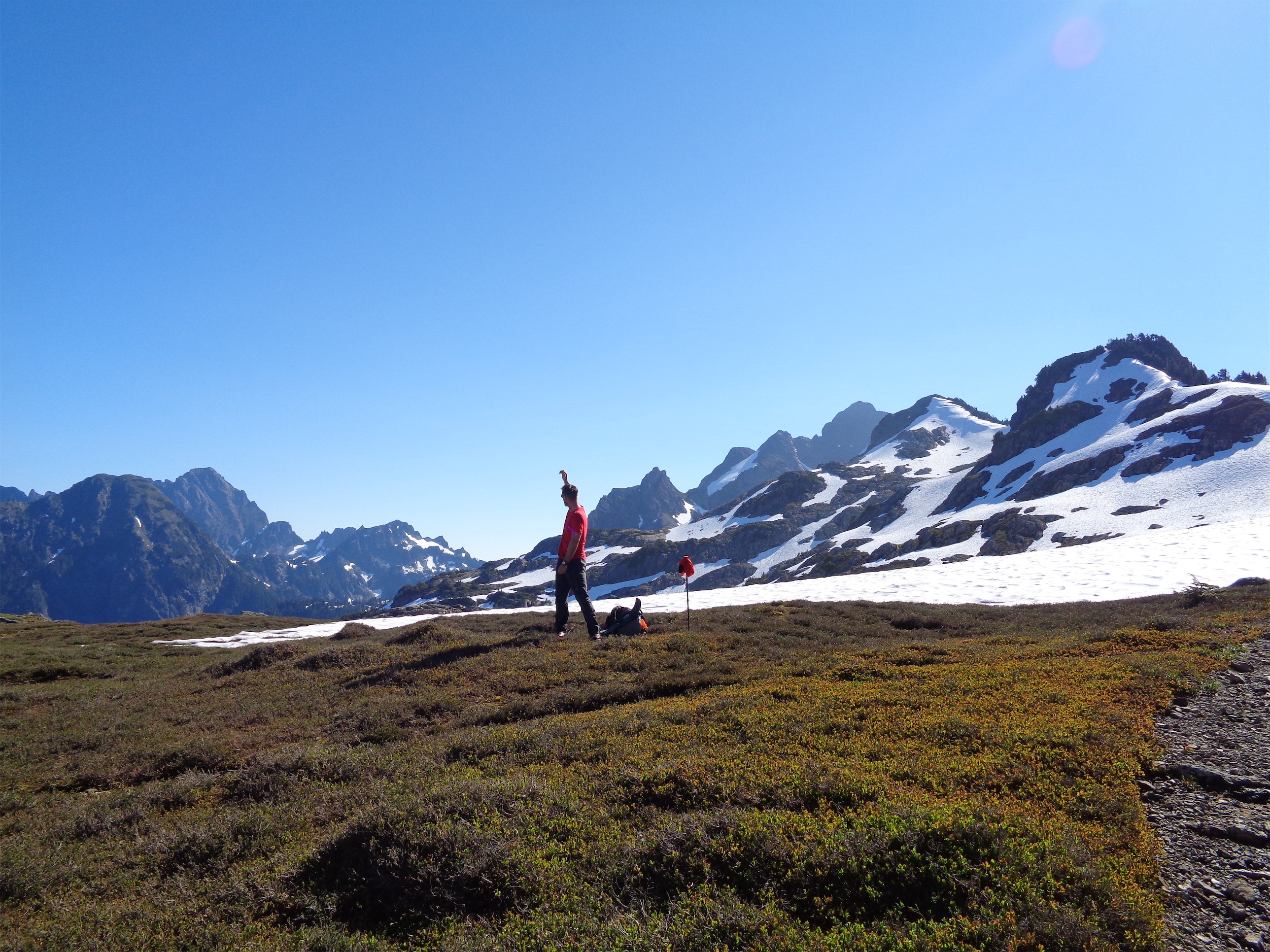
Cal enjoying the views from Goat Flats

Goat Flats Throne
I was happy to snuggle down into my bivvy when we decided to call it before Goat Flats. I brought twice as much food as Calvin, Haley, and Tricia combined, which ended up being a good thing a day and a half later. They let me stuff it in their bear bags, which they hung off a tree. We slept for 5 hours and then had a lazy wakeup with breakfast, coffee, the works. And we started up to Goat Flats, which we reached after an hour of mellow hiking, barely even bushwacking.

Summer trail with patchy snow
We packed up our snacks and started down the summer trail to the lookout. Through the forest it was melted out, but when we popped out on the south side of the ridge it was snow covered. We kicked steps across mellow slopes up to Tin Can Gap, which was partially melted out, enough for wildflowers! At Tin Can Gap we got our first real look at the lookout, perched atop the south summit. Sweet! We weren’t making great time, so we ditched our original plan of traversing the three summits. Oh well. The ropes and cams were relegated to training weight. God dammit.

Tricia pulling some nifty moves in the moat
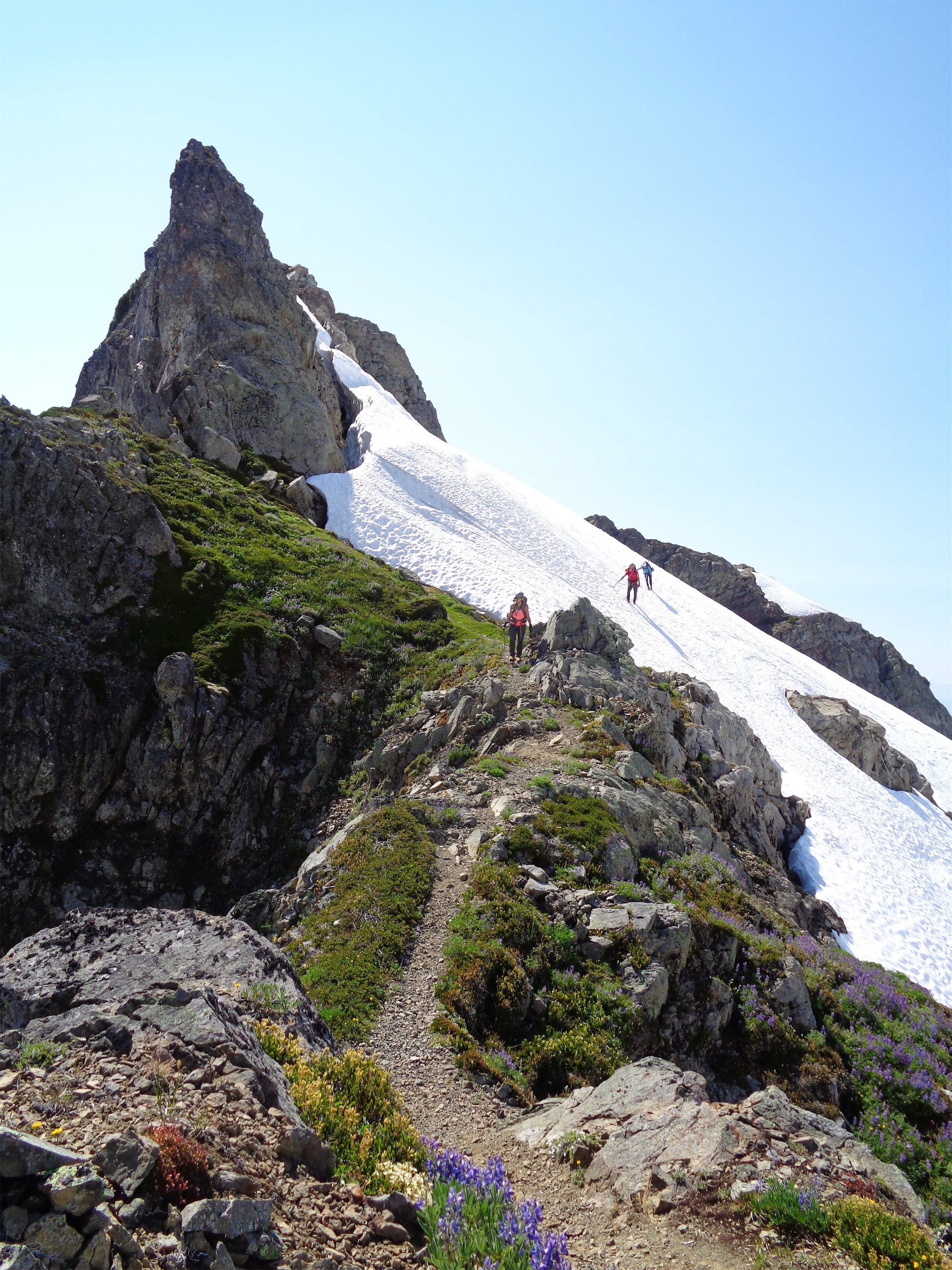
Rather than drop onto the glacier, we stuck with the summer trail. That was our mistake. We expected it to be more melted out, or more snow covered, not the awkward in between we ran into. Decent moats to negotiate, one of which involved a rock that slashed my thumb. It probably needed stitches, it still hasn’t healed, and I’m not sure my thumb will ever be the same shape again. Some steep snow to traverse. Some downclimbing third class scrambles, occasionally with crampons (the worst). Some goats, completely uninterested in us but making us look like slow bumbling fools while they dashed down the fields. And finally, a somewhat melted out trail, surrounded by wildflowers, switchbacking on top of the world. Yes. This is why I was here. I hadn’t been expecting wildflowers! We finally hit a snowfield that took us to the final scramble to the lookout. We had no idea where the ladders were, so we each scrambled a separate path to the top.

Calvin, Tricia, and Haley on moderate snow
I heard Calvin drop one of his classic F bombs. Shit, this wasn’t the top. There was a huge gulley. The good news was he could see the ladders, and we’re idiots, they were right around the corner. I was stuck on a downclimb, I went a little too far with an overnight pack and realized I was not going to be able to scramble down that I just did. Cal tossed me a rope (“what do you need?” “a #1 cam please!” “no, but here’s a few feet of rope”) which I looped around a small horn to fake-rap myself back to safety. Damn downclimbs.

Florida downclimbing in crampons…yay!
We scurried around the corner and bam, there were the ladders. Woo! But don’t be deceived, they’re crooked and squeaky with one or two rungs that feel like they’re toast any day now. And the airy step to the third ladder makes you pause for a split second. But once you’re up the third ladder, you’re at the lookout, and it’s time to relax.
Summer trail!!
The clouds moved in quickly, and we were soon socked in by fog. Total bummer, but hey it makes the lookout more cozy. We hoped it’d clear up in the morning, but until then it was dinner, hot chocolate, alpine cider, mountain trivia (there’s a mountain trivia book up there!) and Haley (still on east coast time) was snoring soundly within 30 minutes.

“do any of these go” (photo credit: Haley)
The recommended waste disposal at the lookout is literally chuck-a-dook. I explained this in a blog post years ago. It’s the most hilarious method, and more convenient for everyone (besides the environment) than blue bagging. Elegantly explained by a piece of paper pinned to the wall of the lookout, you find a nice flat rock, shit on it, and toss it off into the distance, out yonder over the cliffs where the Glacier Waste Treatment Plant takes care of it (aka the Queest Alb Glacier will hide it until it melts out in 100 years, and then there will be slabby boulders scattered with turds).

Ladders! Yay!
The lookout had some old fire-spotting tools, emergency water in the “attic,” a bottle of bottom shelf tequila, some old first aid supplies, and summit registers/log books going back to the 70’s. The approach to this peak used to be via the Boulder River Trail, which I think is so freaking cool. It took you to Tupso Pass, then followed the “current” trail to the lookout. Then FR 41 to Tupso Pass was built, and suddenly the hike was only 16 miles round trip, and it became swamped with traffic. Even last year when someone towed the boulders off the road (hence the newly piled dirt on top of the boulders this year) the lookout saw a huge spike in hikers, which was painfully obvious on the WHC Facebook group and quite evident in the summit register when we flipped through it. The huge washout is only 2 miles from the trailhead, but the boulders and dirt block the road 8 or 9 miles back, effectively doubling the distance of the hike A few guys tried the old Boulder River approach, which I’d love to attempt someday when I have a week to dedicate to brutal North Cascades bushwacking. Yuck. There used to be cabins where Gerkman Creek joins Boulder River, so you could hike a ways in and stay in a shelter before continuing on to Tupso Pass and the eventual lookout. The trail was ravaged by logging and now has several decades of Devil’s Club and brush growth, and it sounds like there isn’t much left. I have to wonder if it would be a more interesting hike than walking/biking FR41 if someone were to blaze it and get some foot traffic started up again. Here is a map that shows the old trail to Tupso Pass (where FR41 currently ends).

Coming up the last stretch to the lookout (photo credit: Haley)
We enjoyed out night of sleep in the lookout, and didn’t even get to meet Alpine Andy, the resident rat. He might be dead, cause I think his legacy started in the 70’s (he was there first!) and I doubt rats live for 40+ years. But we left some crumbs as a sacrifice to Alpine Andy and the mountain gods to forgive us for chucking our dookies onto the glacier.

View of the North peak in the clouds
In the morning we had another lazy start. I had coffee and felt absolutely amazing 30 minutes later. Is this what I’ve been missing my whole life?! Maybe I should start drinking it. We lit the sparklers Tricia brought that we had forgotten to use the previous night, and started down the ladders in the fog. They’re worse when they’re soaking wet, and the scrambley moves are that much more awkward. Haley wore all gray, which sucked for photos. Come on Haley. Florida is no excuse for all gray.

Ladders aren’t always easy

Ask her why she wore gray
We dropped down the snowfield quickly, and found the huge boulder we had scouted out the day before. We figured we could rap down to the glacier and walk across that instead of following the summer trail, which had been a pain in the ass. Cal and I set up a nice double rope rappel, Haley and I went down first to counter balance each other (one on each strand), and Cal and Tricia came next. We pulled the ropes, set up two teams of two, and started across the glacier. Honestly we probably could have downclimbed the talus field, but it was loose and crappy and we had 7 ACLs for 4 people so rapping was easier.
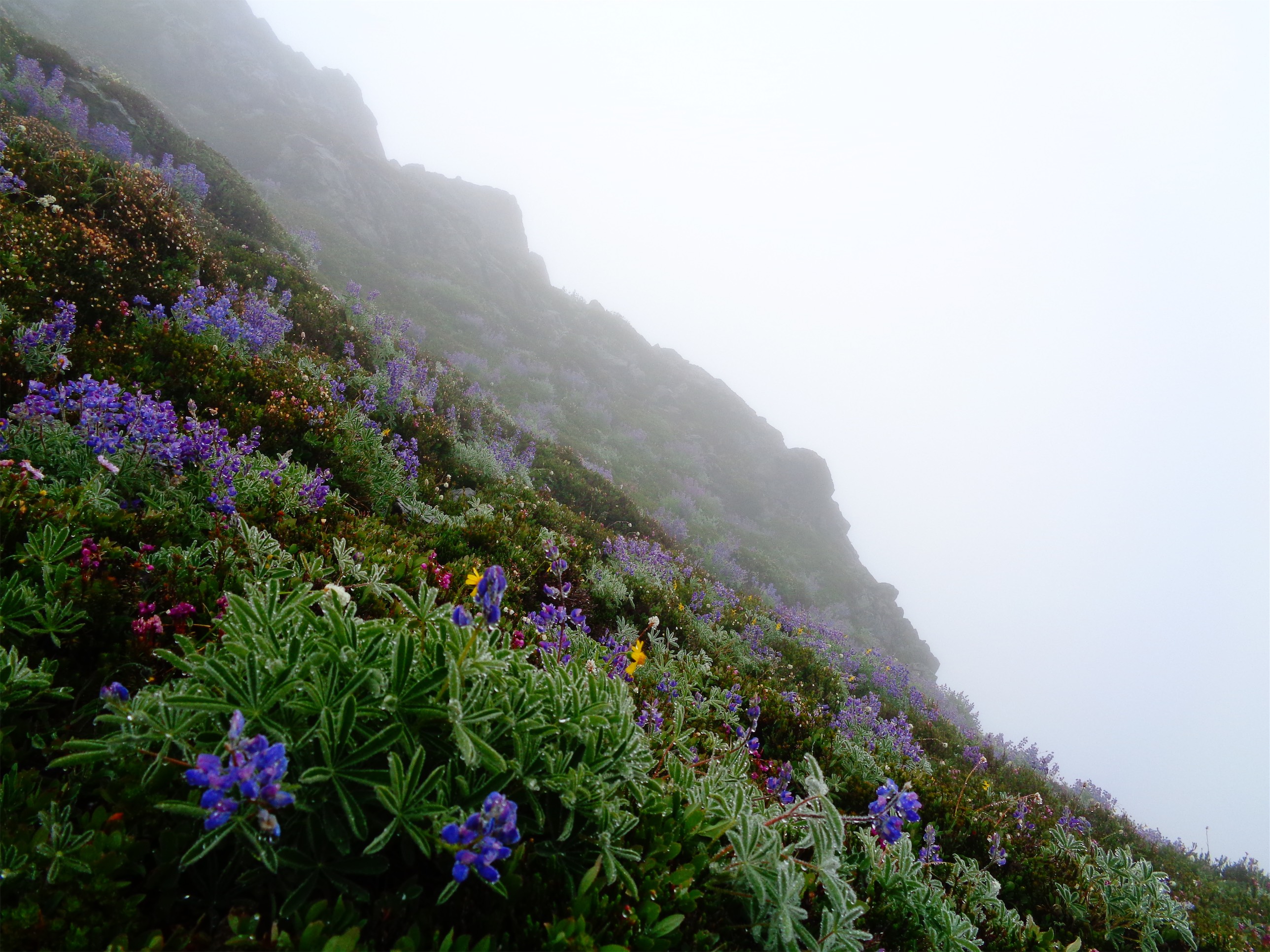
Wildflowers in the mist
That’s what we should have done on the way up. Take the glacier, not the freaking summer trail. It was an easy walk with some stretches of steep snow, but we kicked a sidewalk for everyone and even found a rogue water bottle from a previous party (which, in hindsight, I think we forgot to pick up. Shit). We were back at Tin Can Gap within a few hours, and carried on to Goat Flats. From there, instead of taking our shortcut back down, we took the Meadow Mountain trail. Tricia is just a few months off ACL surgery, and going down that steep ass shortcut probably would have sent her back to the table. The Meadow Mountain trail wasn’t bad to Saddle Lake, where it got a bit brushy for about an hour. The trail appears to bypass the true summit of Meadow Mountain, but it’s honestly not in terrible shape. I started fighting foot fatigue, and finally Haley and I ditched Calvin and Tricia and said we’d meet them back at the car. 20 minutes after we split up I realized I had just told Tricia to eat her last Gu because I had a bunch she could have (I knew Cal was out), and then I took off leaving them with nothing. So I found a nice log that had fallen across the trail, and left several Gus, some shot blocks, and a packet of advil for whatever pains I imagined they were enduring. “It’ll be like a mile to the road” Calvin had said, which had made me laugh. “A mile and 2500ft of elevation loss, right.”

Florida remembering how to walk on snow (taking the glacier back to Tin Can Gap)
It was several hours, with a gnarly blowdown that threw all of us off the trail. Haley and I found the shortcut relatively quickly since there’s a strip through the brush leading down to the next switchback (“nothing leaves traces that obvious except for people… it must be to the trail”) but Calvin and Tricia weren’t so lucky. It had occurred to me to maybe leave a rock arrow on the trail or some sign to turn off there to avoid the blowdown, but I’m a lazy asshole.

Calvin jogging across Goat Flats to get water
“I see the road!!” Haley sounded excited. Meadow Mountain would drop us off on the old road about two miles from our cars, so we wanted to reach the road by dark. But the “road” she saw was a log. Come on, Florida, you’re the one with the good eyesight. Finally she saw the road for real (“shut up I’m not listening until OH MY GOD IT IS THE ROAD!!!”) and we hustled down to it, only to begin the real slog. My feet were killing me in my damn mountaineering boots, and we had a forest road to walk. The cedar tree was the real relief, because it was so freaking cool. I started counting the rings but lost interest at ring #150, which was like 1/3-1/4 of the way across the log, so we lowballed the age at 550 years. EDIT: Another guy counted the rings and got 745!! A tree that was 745 years old! Hoooooolyyyy Shiiiit. Insane seeing something that massive. I want to cut a slice and make a table out of it.

Holy shit!! It IS the road!
We got back to the car just before dark, where I pulled out my car camping stuff and we sat down and destroyed a box of cheez its. We placed bets on when Tricia and Calvin would be back. I nailed it with a guess of 10:45. They got back to us and it turned out they had tried to radio and text and everything telling us to just go home, but we hadn’t gotten any of the communication. Oh well, it’s 11pm on a Sunday and I’m lying on a forest road looking at the stars, it could be worse.

745 years old!! Me for scale (photo credit: Haley)
I bailed pretty quickly. The drive out felt like it took forever. I passed a guy in a flannel on the side of the road just staring off into the dark. People are fucking terrifying. But hey, the trip was awesome, despite the surprisingly long days and abject lack of views at the lookout. There’s a fair bit of history up there, and now that I know the route (aka drop to the glacier if it’s early season or very snowy, it’ll save you SO much time) it’ll be faster next time. I’d love to see how much Goat Flats has been restored since the road closure. I am under the impression it used to be insanely popular, and the goat herds had actually migrated and are just recently returning to the area. It’s amazing that the lookout is kept in such good shape by volunteers, and I love that that’s the case. It’s too bad more lookouts like that one weren’t preserved.
Tough to be unhappy in such a spectacular place!
So if you have a two day weekend, it’s definitely worth checking out, especially as the trail melts out. The glacier would be a great ski too if it’s early season, and snow might make the approach through the woods easier (if it’s consolidated – powder would be a bitch). There is a limited supply of flat rocks up there for chuckadook though, so get up there while supplies last!

Who’s the real dookie? That cedar tree is the real dookie! Great photos.
LikeLike
You should return in clearer weather. And go climb the North Peak (exposed, easy class 4 route). You can traverse the glacier to come back onto the route up to the lookout.
LikeLike
Definitely! Have you been up there?? The full traverse from south to north was our original goal, we brought ropes and cams and everything (there’s a nice 5.4 route up the north peak too). But it took us so long 😦 If we had just dropped across the glacier from Tin Can Gap instead of following the summer trail we’d have had time. We’ll be back!
LikeLike
Did you use the bushes as a mattress? hahaha Did you see any other people on the trail or at the lookout? I can’t believe you bushwacked straight from the road closure to goat flats! nice write up!
LikeLike
Looks like a great route!
Great photo of Calvin, Tricia, and Haley on moderate snow
LikeLike