


Yeah yeah no one reads blogs on Sundays… but I’m excited about this one and it’s been a while so let’s go for it. Oakes is a relatively short peak in the North Cascades that has been gaining popularity over the past few years, presumably due to its amazing views and the crazy increase in people getting outdoors recently. There is no trail, but a fairly obvious route given the terrain. It has been on my list for a few years, but finding sunshine in winter, people who are willing to forego a ski day or larger objectives, and the motivation for >5000ft of bushwhacking is a difficult task. Surprising? No. Well, finally the planets aligned, and after a weekend of trying to ski ice we resigned ourselves to booting up stuff. We made a great attempt on Baring last weekend (maybe a post for another time) but had to bail before the summit, and that bluebird day of booting gave me the hunger for a winter summit. We knew most snow would be shit for skiing since there wasn’t any precip during the week, so we figured we’d pick another “cardio peak” to try and get in some elevation and views. Oakes was a perfect choice.

- Distance: 7.5mi round trip
- Elevation gain: 5000ft (5600ft highest point)
- Weather: 20’s and sunny
- Commute from Seattle: 2:30
- Did I Trip: No faceplants thanks to a trusty walking stick. Many postholes.
We left Seattle Friday evening so we could trailhead camp given the good weather. Fell asleep by 11, my bag was so perfectly cozy, woke up to a dozen alarms we snoozed from 5:11am (i don’t… know why my alarm was set for 5:11 exactly) until about 7am since we decided bushwhacking in the dark sounded shitty and we were confident we’d be able to finish within the 9hrs of daylight that Washington has right now. The muscle memory of my legs with regards to hiking/mountaineering seems stronger than the actual muscles of my legs, so I figured worst case scenario I’d be able to hobble down feeling fine and cry about it the next two days when I couldn’t go from standing to sitting without falling part of the way.
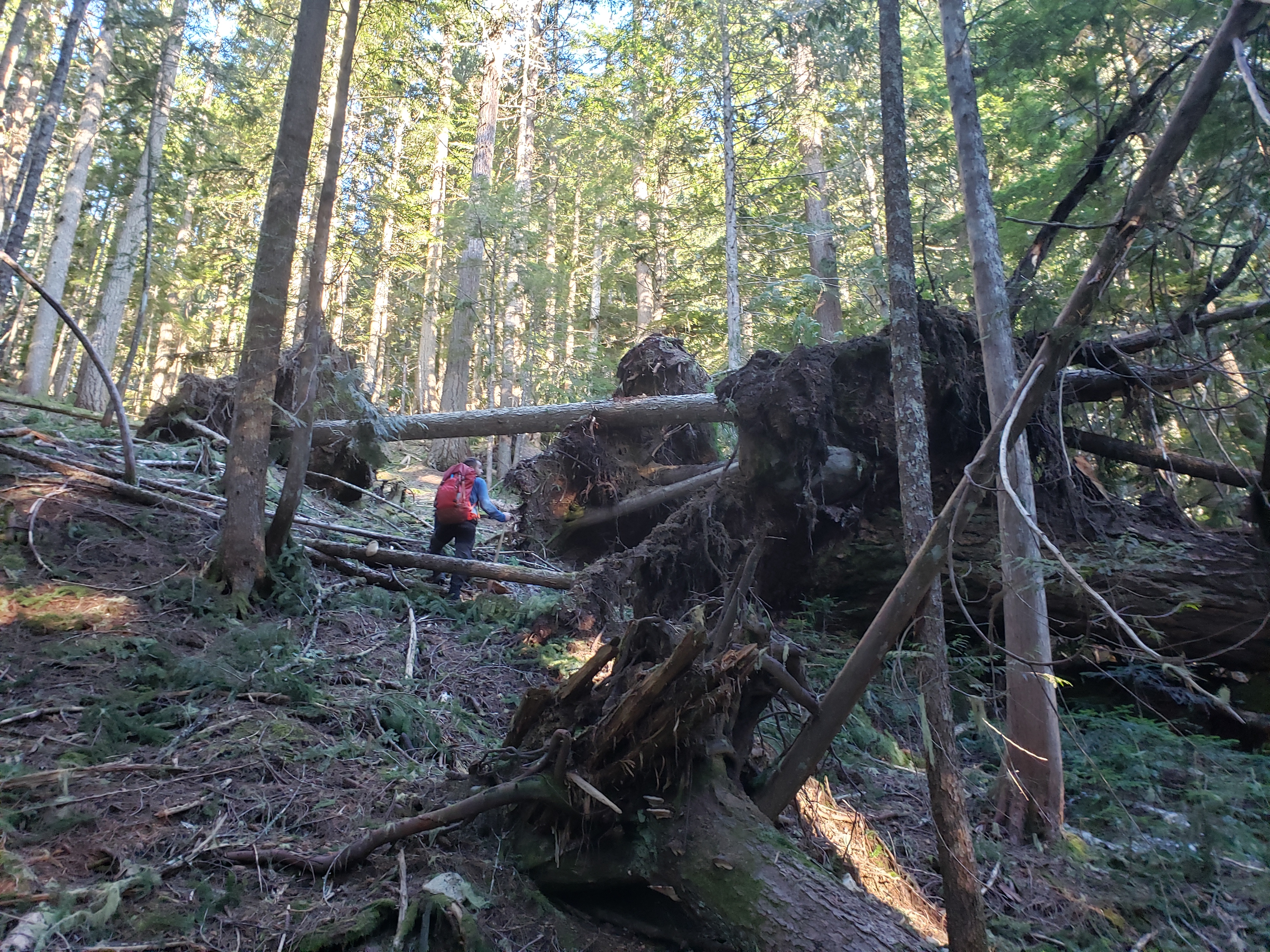
We hopped out of the truck around 7am. “Shit, are my trekking poles in the cab? Or did I forget them?” Robert opened the door to peek. “No dork poles in here.” Crap. I love those on bushwhacks and steep shit. They save my knees, they let me whack plants, they make sidehilling marginally more tolerable, I can lean on them and try to crack my back which has felt like it’s 65 years old lately, probably because 85% of my life now consists of staring at a computer screen and occasionally migrating from my basement desk to my breakfast nook desk to my countertop desk which are all within ~20ft of each other as I work from my (beloved, adorable, best ever) tiny house. But they were sitting in my trunk 100 miles away, so there I was, newly in the market for a walking stick. We crossed Oakes Creek running over the road (and creating some seriously slick frozen spots) and started looking for a good way to enter the forest.

We went into the woods maybe 100ft left of the river (looking upstream). It was schwacky, but not bad. There was ankle-to-waist-high vine maple for the first couple hundred feet (I learned I need to strengthen my soccer-ball-kicking muscles aka the ones that kick through vines) but the forest soon opened up to a moss carpet and eventually a tiny icy layer of very annoying snow. We found a bootpath along a mini-ridge in the forest which was beautiful and cruiser for a half hour or so before it disappeared again. Robert found a “sword” (a triangular piece of cedar good for whacking/chopping other vegetation) as well as a walking stick for me. Two sticks actually, one was light and the other was heavy but more durable. I chose light and fast, plus it had the perfect little nub for my fingers to rest on like a trekking pole. I dubbed it Pope John Pole II (Donald Stump felt like a cop-out, plus I’d rather be accompanied by a Pope than Trump on a climb I guess). Robert deemed his Stick Cheney, and it turned from a source of amusement fighting trees to a hiking and mountaineering tool. Thanks to my trusty stick, I was saved from multiple face plants, and the first 2000ft of gain actually went by pretty quickly in my head (2hrs in real life haaa) and soon enough we were at the first road crossing.
Despite the bushwhack/off trail nature of this peak, there is a web of roads that switchback up it from the south. You can snowshoe those, but it’s something gross like 18 miles of road walk. I have no idea what the status of those roads is for driving/snowmobiling/biking, even in summer. I assume they’re blocked, otherwise I think this peak would get a lot more summer traffic knowing you could drive to 1,000ft below the summit.
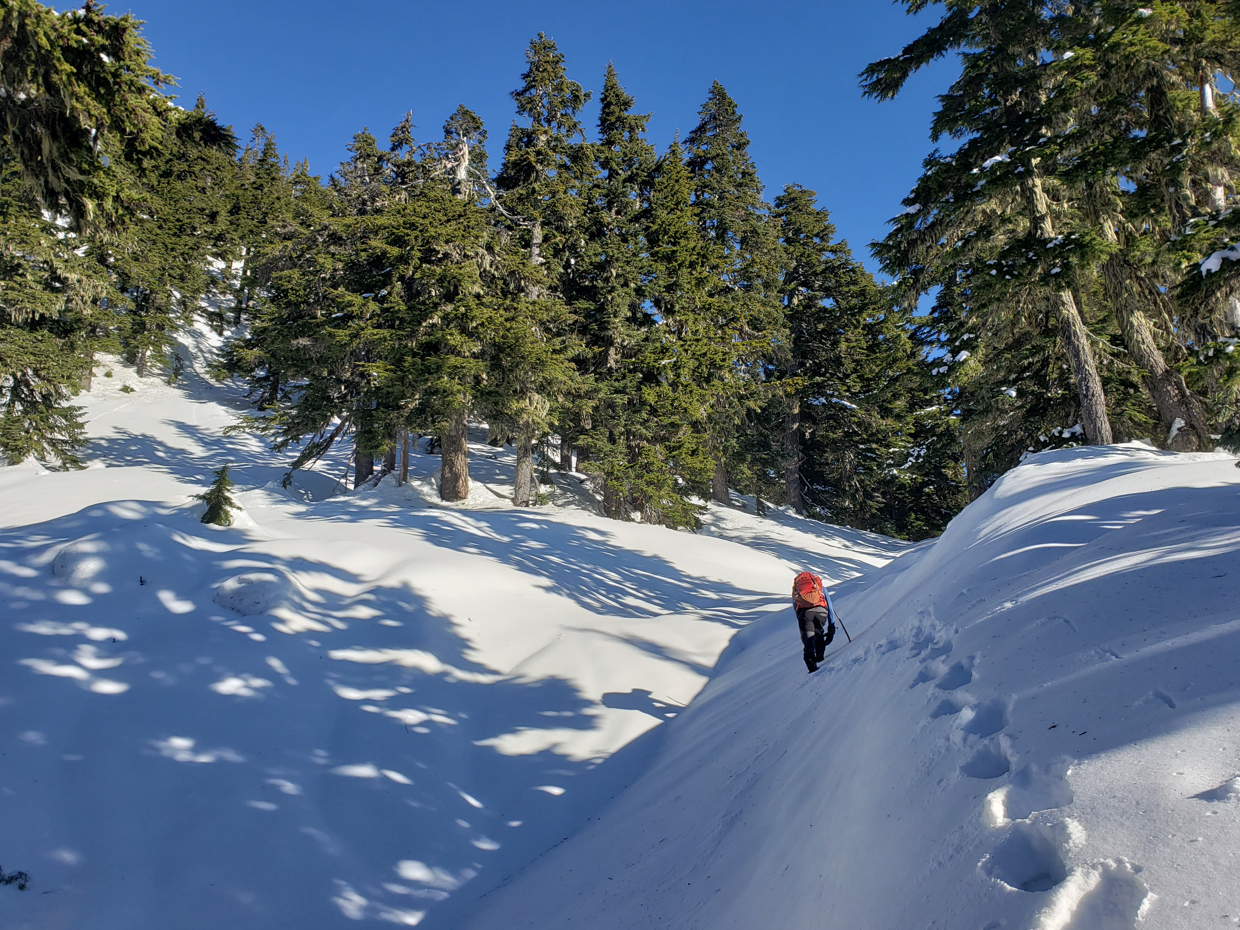
The bushwhacking between road crossings was more mellow, and we were finally starting to get glimpses of the views to come. Snow started almost perfect at the first road, but it was good snow for booting (besides the occasional tree well/posthole). We are some hi-chews, chugged some water, and kept moving. I felt good, but slow. Like 2018 or 2019 Eve would have cruised up this in a few hours, 2020 eve isn’t sure she existed, and 2021 eve is clawing her way back into existence after a sloooow year of climbing. But I figure 5k in a day off trail would be a good start.

Past the last road crossing, the route finally steepens. Nothing comparable to Baring the prior weekend (which was funny, Baring made Oakes seem moderate) but definitely a lot of sustained steep snow. I can see why people used to use those big ol ice axes on top of huge wizard-staff style alpenstocks, the walking stick cut nicely into snow. Better than a trekking pole for sure. We had ice axes, but never felt compelled to get them out. There were several icy stretches that were fine going up but would suck to come down without crampons, so I committed to donning crampons at the summit even though I knew I wouldn’t want to. (spoiler: it was a good call) The snow alternated between that frozen crap and bucket steps (aka really good booting conditions), and while trailbreaking wasn’t easy, Robert insisted on doing all of it. To build fitness, or character, or something. I offered to give it a go but I mean… I’m not going to complain if you want to break the entire trail and I just have to climb stairs behind you. In fact that sounds lovely. Except that I get complacent, and then I posthole purely because I stop paying attention to walking. So you can’t win em all.

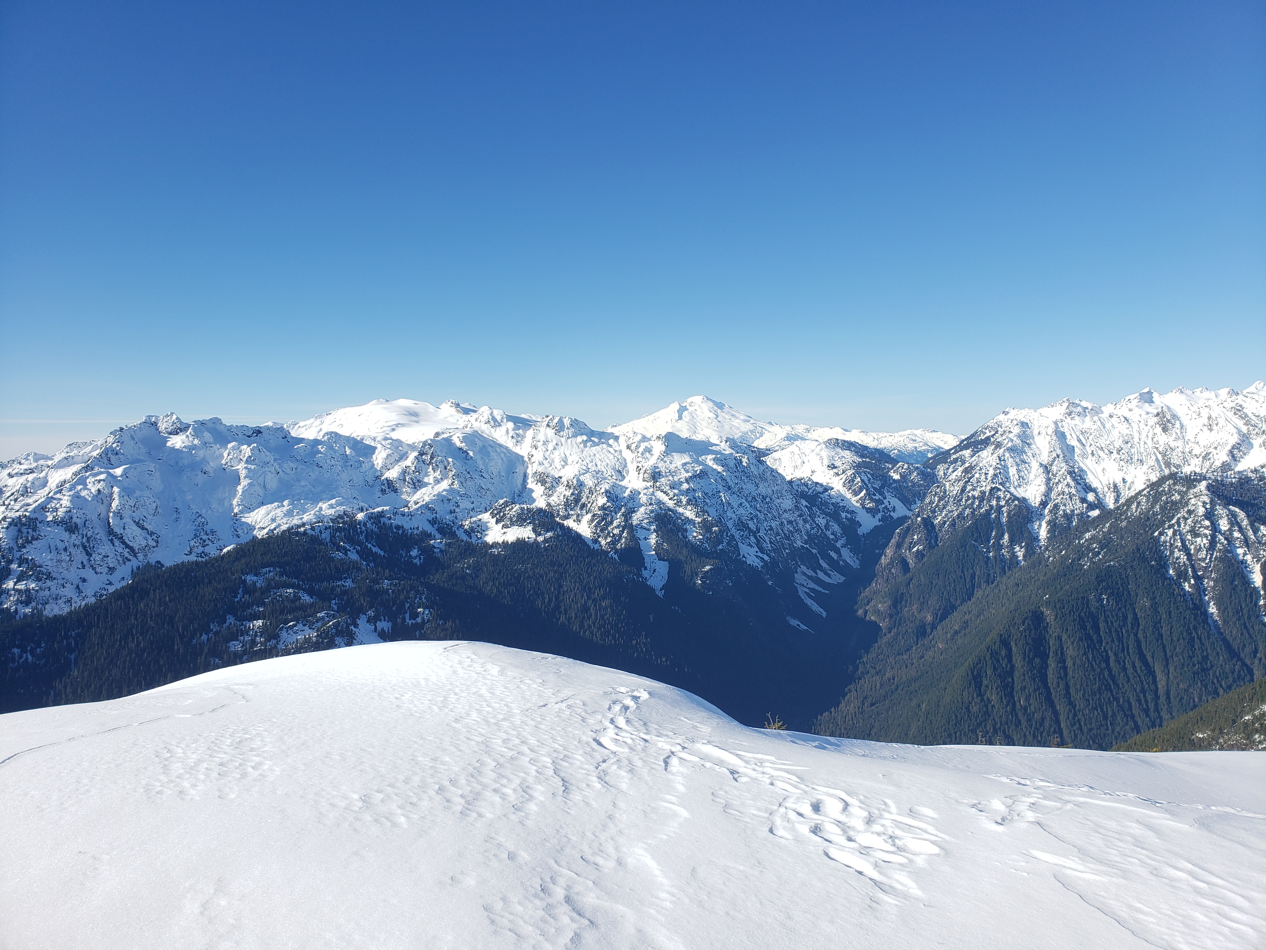
Okay here’s the one downer about Oakes: Views don’t really happen until like the last 100 vertical feet, if that. That’s why you should just look at it as a cardio trip. But when you get to the top. Ohhhh my god. Everything due north of Oakes is a surprise as you crest the summit. You can see Bacon and Baker and the very tip of Shuksan, and Blum looks enormous, and the entire Mystery traverse is laid out in front of you. And Despair, Triumph, and Thornton peak look staggeringly massive and truly alpine with jagged, icy, rocky spines. The topographical relief of the North Cascades is absurd. At some point I said to Robert “How is it that we’re on a peak that isn’t even 6,000ft tall and I feel like we’re on top of the world in the middle of nowhere?” “…Because it’s the North Cascades.” And he’s right. They’re the best.
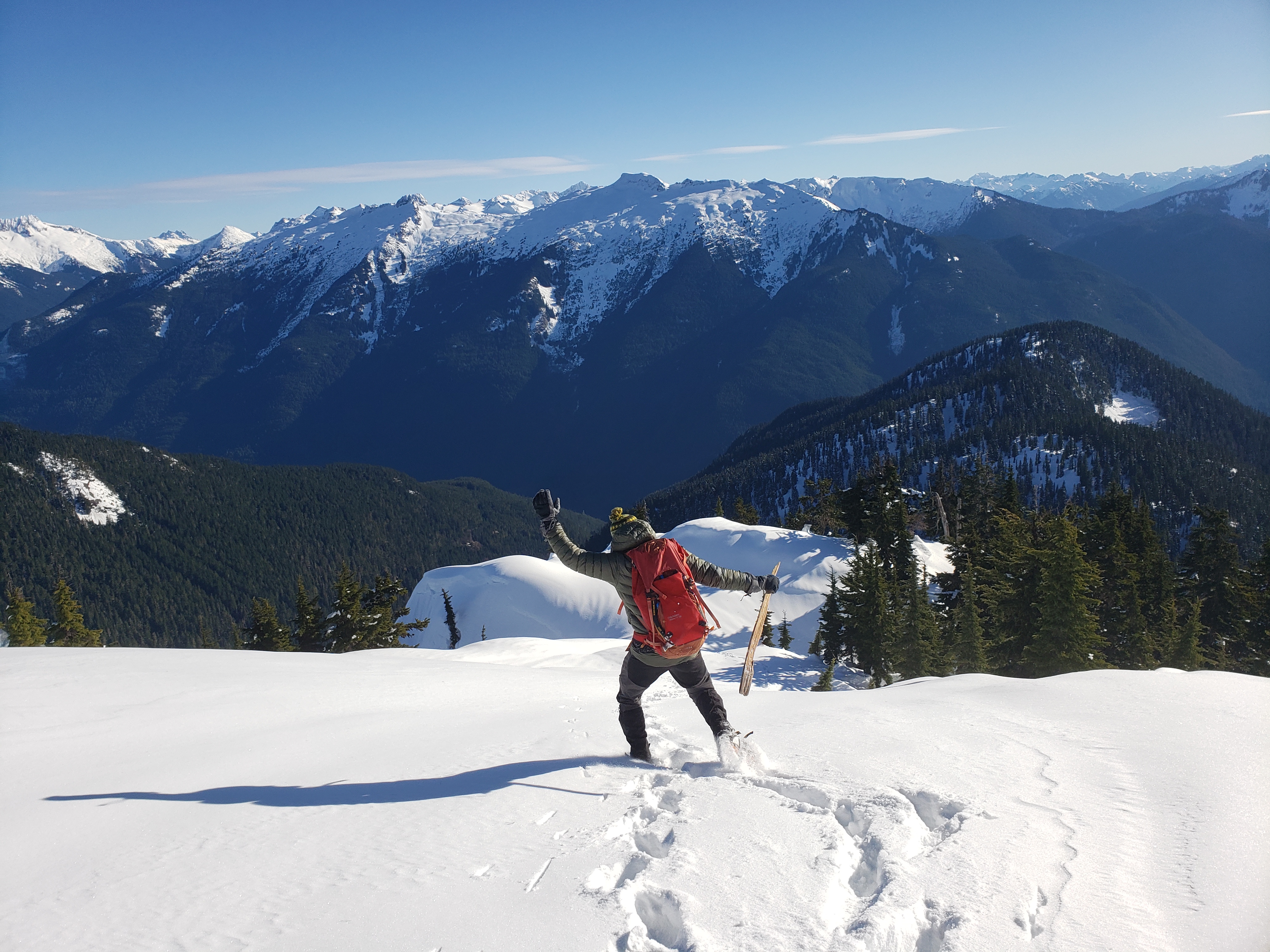
We only spent ~30 min at the summit. I could have spent hours. The views were so awesome and I so desperately wanted to see sunset. It hurt to even think about it. But it was almost 1pm, and we wanted to be back at the car within daylight, so we started back down. We figured we could get down faster than we got up, especially given how much we were dragging the last 1,000ft.
We ran into a group of four about 2000ft below the summit. Right after Robert said “so at this point think it’s safe to say there’s no one else up here? By this time of day they’d all have turned around if they weren’t within 1,000ft unless they want to come down in the dark…” It took us probably 90min, maybe longer to top out from where they were, but they’d have the benefit of a solid bootpack and no navigation required which would have saved us a lot of time. But it was still almost 2pm, and I wondered if they’d summit or bail because the lower part of the descent would be miserable in the dark. Or maybe they were aiming for sunset views, in which case I hope they see this and share pics.

We literally cut our time in half on the way down, and that includes an unfortunate 30min terrible sidehilling-through-vine-maple-slide-alder detour because we dropped too low without contouring west. We had found a bootpath, and when it ended, I didn’t realize how firmly skiier’s right our track turned. We kept following the line of fall, and so when we started a downward traverse to the right to meet the route, we ended up just paralleling the route through 40 degree slopes on the side of a huge drainage until we finally rounded back onto the mellow slope the route follows. It probably would have been easier to just climb up the drainage back to the “face” that the route follows. The route basically threads the needle between 30-50 degree forest and snow. If you stick to it you’ll be fine, if you get dragged down into the drainage because you weren’t paying attention/thought it didn’t matter then you’re going to have a bad time sidehilling with walking sticks slipping on slide alder grasping at plants like Peter clinging to the cliff in Forgetting Sarah Marshall. Always the optimist I laughed an commented at least slide alder makes great veggie belays. But it doesn’t count, because we wouldn’t need veggie belays if there were no slide alder. You don’t get credit for solving the issue you constantly cause. Stupid alder.

I was starting to feel my dehydration, and my face was burning and stinging from sweat (thank you, dry skin). On the bright side, the normal route suddenly seemed basically flat after the shit we had just been through. It still required several re-calibrations of expectations (we’re less than 1000 vertical feet away now right? Uhhh more like 1700 feet away.. now we’re like 500ft away right? uhh more like 750… okay now we’re definitely within 100ft uh sorry more like 300… god dammit). But we found intermittent bootpaths again (where were you on the way up!?) and even some blazes, and suddenly we saw cars! The forest road! Water! Sneakers! Dry socks! Ahhhh! Changing footwear felt so good. We drove to the first gas station to stock up on drinks and snacks because we were both starving and had barely drank/snacked on the hike.
This hike FAR surpassed my expectations. The views were better than I thought, it wasn’t nearly as steep/miserable as I expected (though it does gain 5k ft in 3.5 miles), and we had perfect conditions for it. Highly recommend to anyone looking for a winter workout with some of the most stellar views you can get in a day trip, with that sense of adventure that comes from being entirely off trail on a peak that not many have climbed before. At least, if you’re willing to sacrifice a ski day. Or want to carrys kis 5k ft for max 1000ft of skiing and that’s being generous, because 200 will be open and the other 800 will be trees with varying snow conditions. Enjoy!


Great stuff Eve! Gpx track anywhere?
LikeLiked by 1 person
I stole them from peakbagger this time around. Stayed naturally pretty darn close to their tracks besides getting sucked into the huge gully on the way down. Glad we had the track to show how far we had to traverse to skiier’s right or we’d have had a baaaaad day (and maybe night) https://www.peakbagger.com/climber/ascent.aspx?aid=951534 (Steven Song, I trust his beta haha)
https://www.peakbagger.com/climber/ascent.aspx?aid=1330175
LikeLike
Really nice post and looks like a nice route!
Also, the photo looking down at the Skagit Valley is really stunning!
Thanks for sharing
LikeLiked by 1 person