
Lee coming around a bend
Mt. Pugh (also known by its hilariously awesome native name, Da Klagwatts) has been on my list since way back in September, when I spent what was probably several hours every day looking at pretty much every hike on wta.org and organizing every one I wanted to do in a word document. That was the beginning of an era, really. Now I’ve branched out to summitpost and old maps and word of mouth, but I can thank the WTA trip reports for lighting the fire under my ass. And Pugh, interestingly, was one that I marked specifically as “maybe you shouldn’t do this alone, looks like it might be a difficult one.” All I knew was that it had a scramble at the top and some exposure, and my newbie hiking brain ranked it above the rest. Back at this point, I was your casual Kendall Katwalk/Annette Lake/Mt. McCausland hiker. If it even occurred to me that I had lost the trail, I’d get anxious. Now losing the trail is just a matter of fact, and I clamber back to wherever I went wrong.
- Distance: 11 miles round trip
- Elevation: 5300ft gain, 7201ft highest point
- Weather: 70’s and sunny
- Commute from Seattle: 2:15
- Did I Trip: Once on the way up, once on the way down. No faceplants.

Starting out through the trees
Well, that was nine months ago. Now it was 6/17/2015. Pugh sounded like a walk in the park at this point, and it was time to give it a go. I expected to be solo, but Lee was free this afternoon, and had never done a scramble before. Perfect. We were planning a tentative trip to Gothic Basin to tackle Gothic Peak and Del Campo and I figured this would be the perfect way to whet her appetite. Or test her limits, as it turned out. I knew she was physically capable of it and wouldn’t be in danger, so I figured we’d play it by ear. She’s the type of friend I can trust to proclaim “eff you Eve, I’m not doing this part” if I push her too far, so I don’t have to worry about peer pressure. I’m sure I’ve said it before, but I never want to be the one who has someone follow me outside of their comfort zone just because I was doing it. I can be an idiot.
We got to the trailhead around 1:30pm. Yeah, late start, I know. We had headlamps. Lee joked that she wasn’t going to bring hers, but knowing me, she should be prepared for anything, and tossed it in her pack just before she left. Also, we drove right past the damn parking area the first time around. It’s on the side of the road, not at the end! There’s a nice turnaround at the end though and someone was camping right there. I had to wonder if they were chilling in their tent while we got out, Lee peed, I checked the map, and eventually turned my bright yellow loud ass car around.
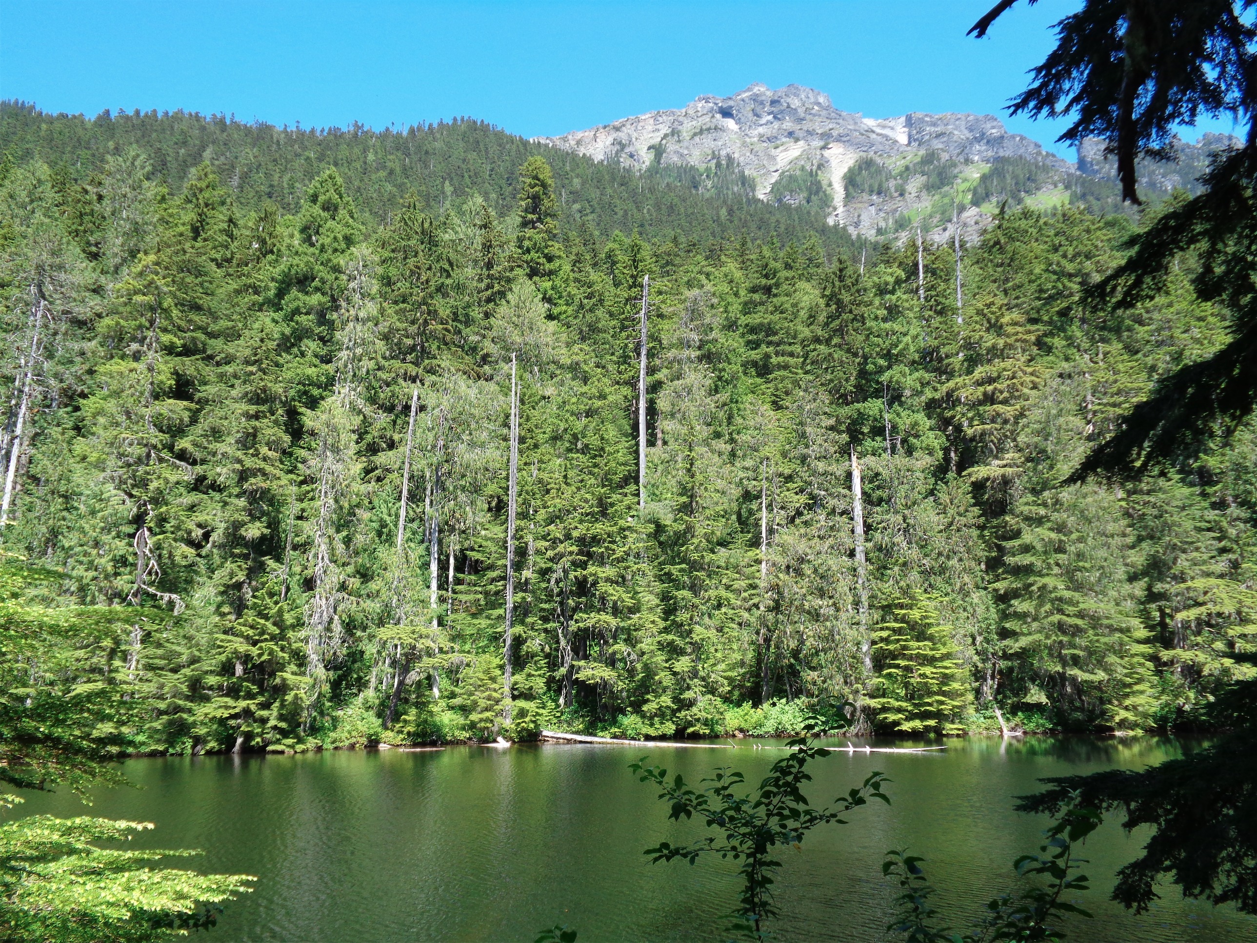
Lake Metan
The trail starts off through forest. The growth isn’t too thick (but it’s still bright green, don’t worry) and the trail is unbelievably soft dirt. There are a few small waterfalls/creeks in the beginning, but once you reach Lake Metan, you’re on your own for water. The lake pops up a little after 1.5 miles in, just a small brown lake with the shoulder of Pugh (I don’t think you can see the true summit) peeking over it. Head left at the lake (right will take you to campsites, I believe) to stay on the Pugh trail.
We head some scuffing in the underbrush and something ran across the trail. I probably wouldn’t have noticed if it weren’t for Lee’s shocked GASP “HOLY SHIT WHAT IS THAT” and we stared at it until it registered “oh OH wait it’s a toad COOL!” We had heard croaking but I didn’t expect to see one. Nor did I expect the jarring shot of adrenaline that apparently accompanies tiny animals in the woods.

Heading up to the pass, Sloan peeking around the corner
The remainder of the trail was uneventful in terms of wildlife, but amazing in terms of scenery. Honestly, it didn’t feel as steep as I had expected, and it would have been completely runnable had I been solo. The forested trail continues for another mile and a half, where you reach the bottom of the slope that leads up to Stujack Pass. We had glimpses of peaks through the trees, but here’s where it opens up. The trail is suddenly rockier with scree-covered sections, and finally starts gaining altitude quickly.
And the views! Mt. Forgotten is directly south across the valley, and you can see straight west to Whitehorse and Three Fingers. Which, as a side note, I flew over – I was writing this while on a plane a few days ago! Luckily the guy next to me (in the window seat, lucky bastard) saw my face light up and let me point out all of the peaks I could recognize. Anyway, as you get higher, you can see Sloan sticking out beyond the slopes of Pugh, and the Monte Cristos just next to that. You’re hiking up a narrow trail surrounded by green and wildflowers, which is pretty amazing in itself. I saw thistle blooming for the first time in my life! Much more purple than I expected. We took frequent water breaks, and I chose possibly the worst scrubby scree section for a bathroom break. And of course, fifteen minutes later, we were at Stujack Pass.

White Chuck framed by Baker and Shuksan if you look closely

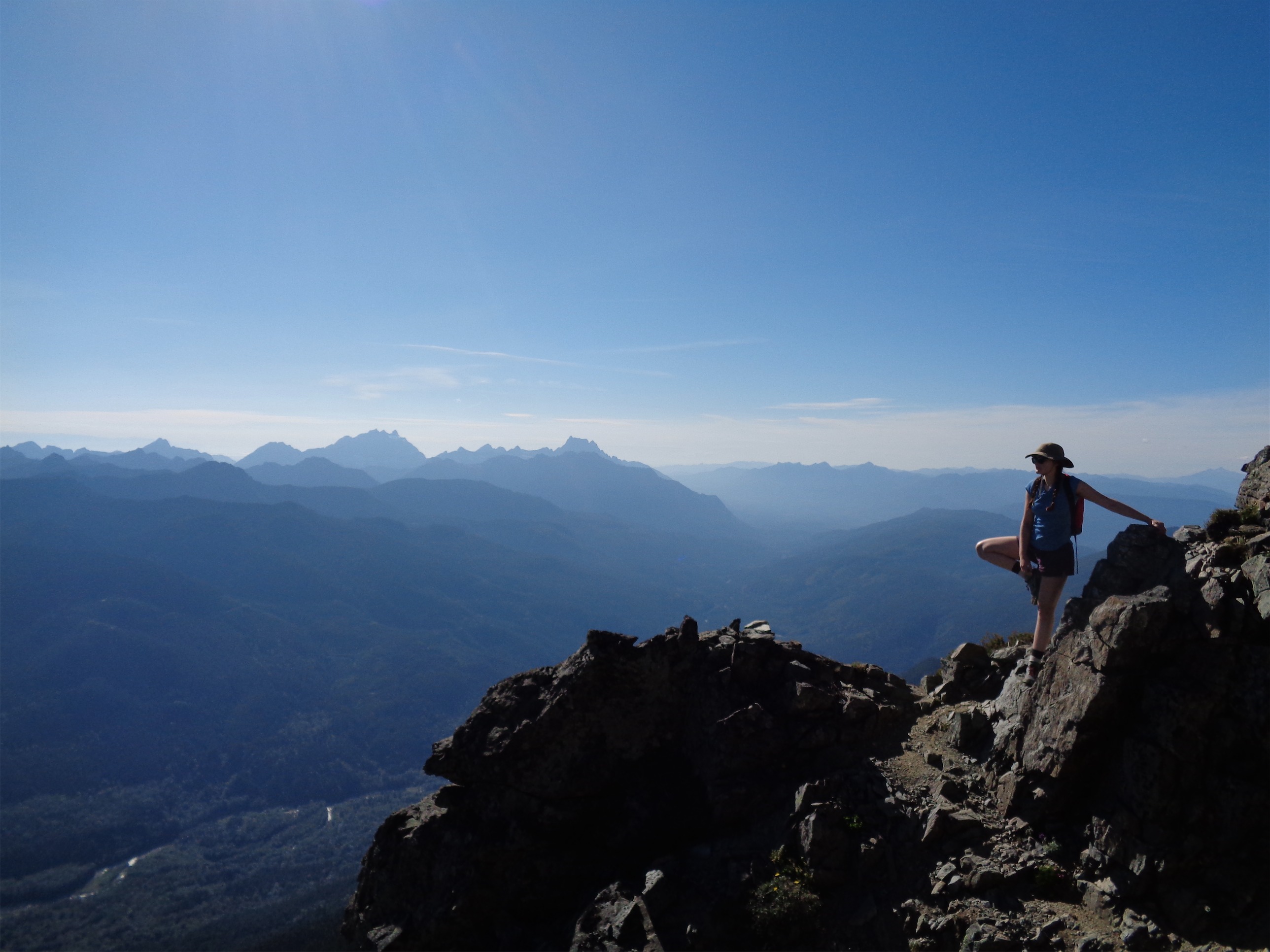
Lee along the ridge
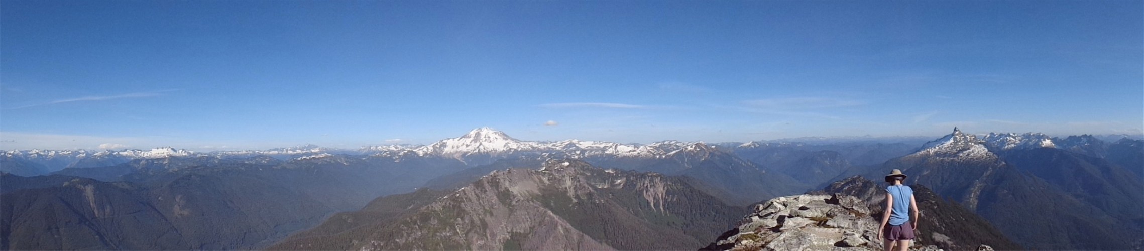
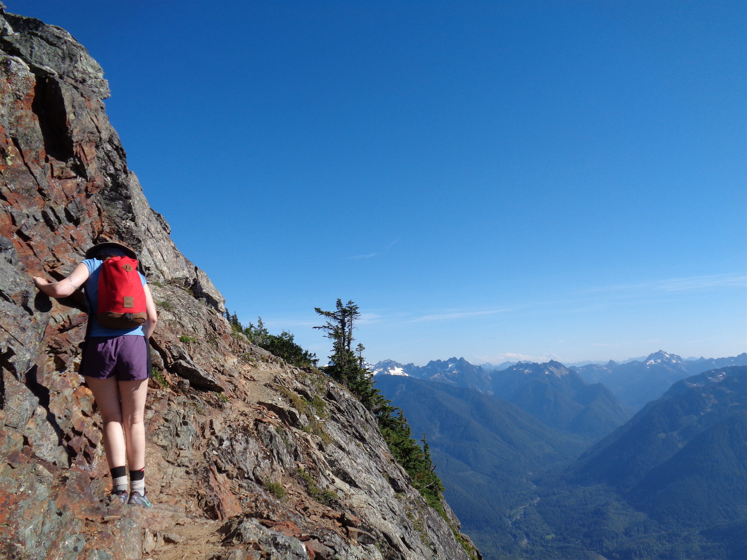
Gaining the ridge, the first peak you see is White Chuck, which is less impressive when it’s summer and not covered in snow. But framing White Chuck are Baker and Shuksan. Head right to follow the ridge, and soon you enter the Glacier Peak Wilderness. One of the best wildernesses. The trail up here narrows, and is under some tree cover at first, until you break out along the knife edge part. Which, god dammit, I will run someday. It’s a narrow rocky trail with a bit of exposure, but you’re on top of the world surrounded by 360-degree mountain views and it’s definitely runnable if exposure doesn’t bother you. Rolling ups and downs, nothing too steep, just make sure you trust your footing. I snapped plenty of pictures of Lee and the peaks in every direction. Turns out Lee has a bit of a fear of heights, and from the ridge to the top was a mental battle every step of the way. I knew she was capable of it, it just depended how her mental war with instinct went with every step. I learned that the phrase “I don’t love this part” is Lee’s way of saying “holy shit am I really doing this I’m freaking out.”
Ridges all day
Looking down at the Straight Glacier
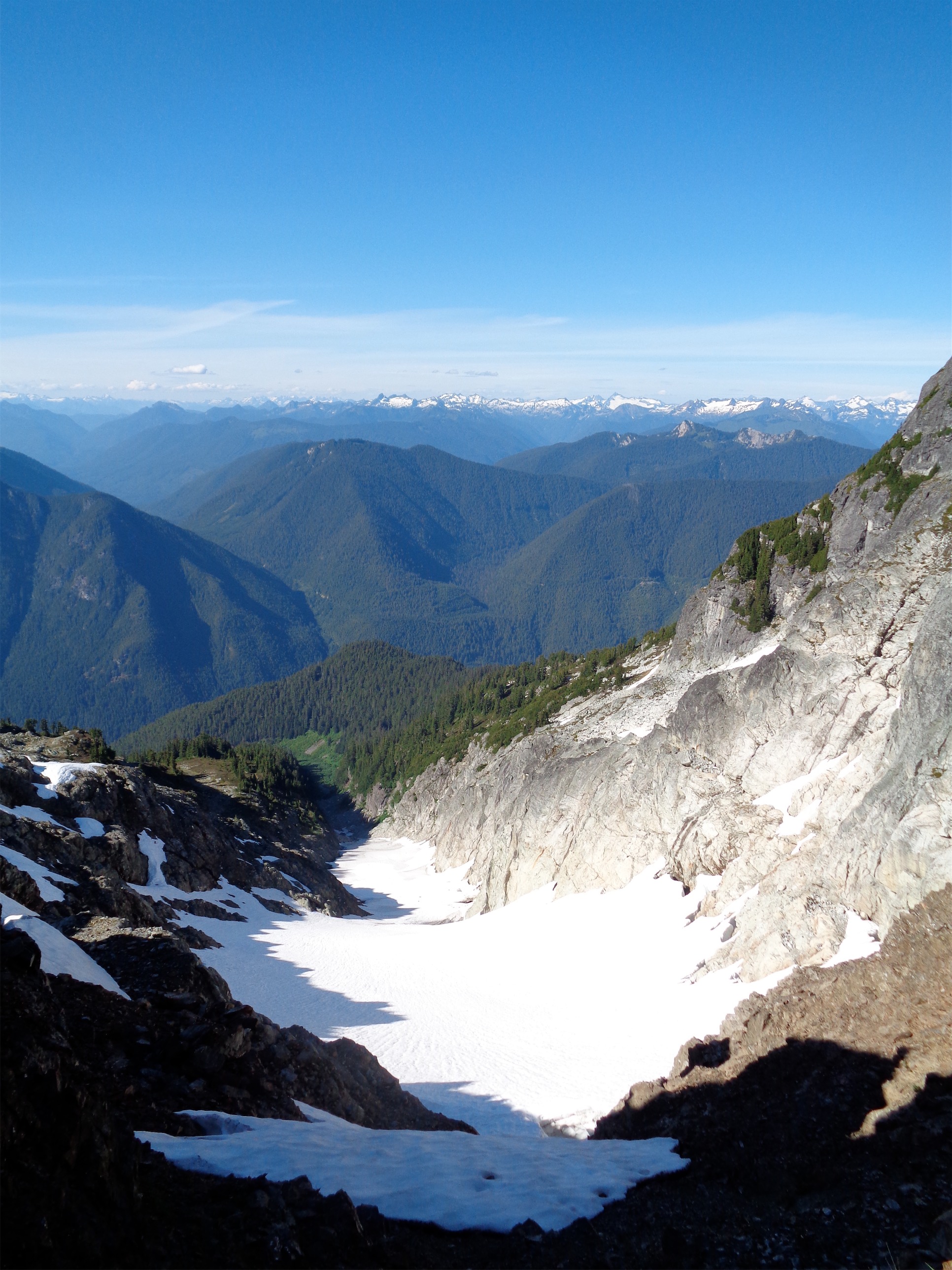
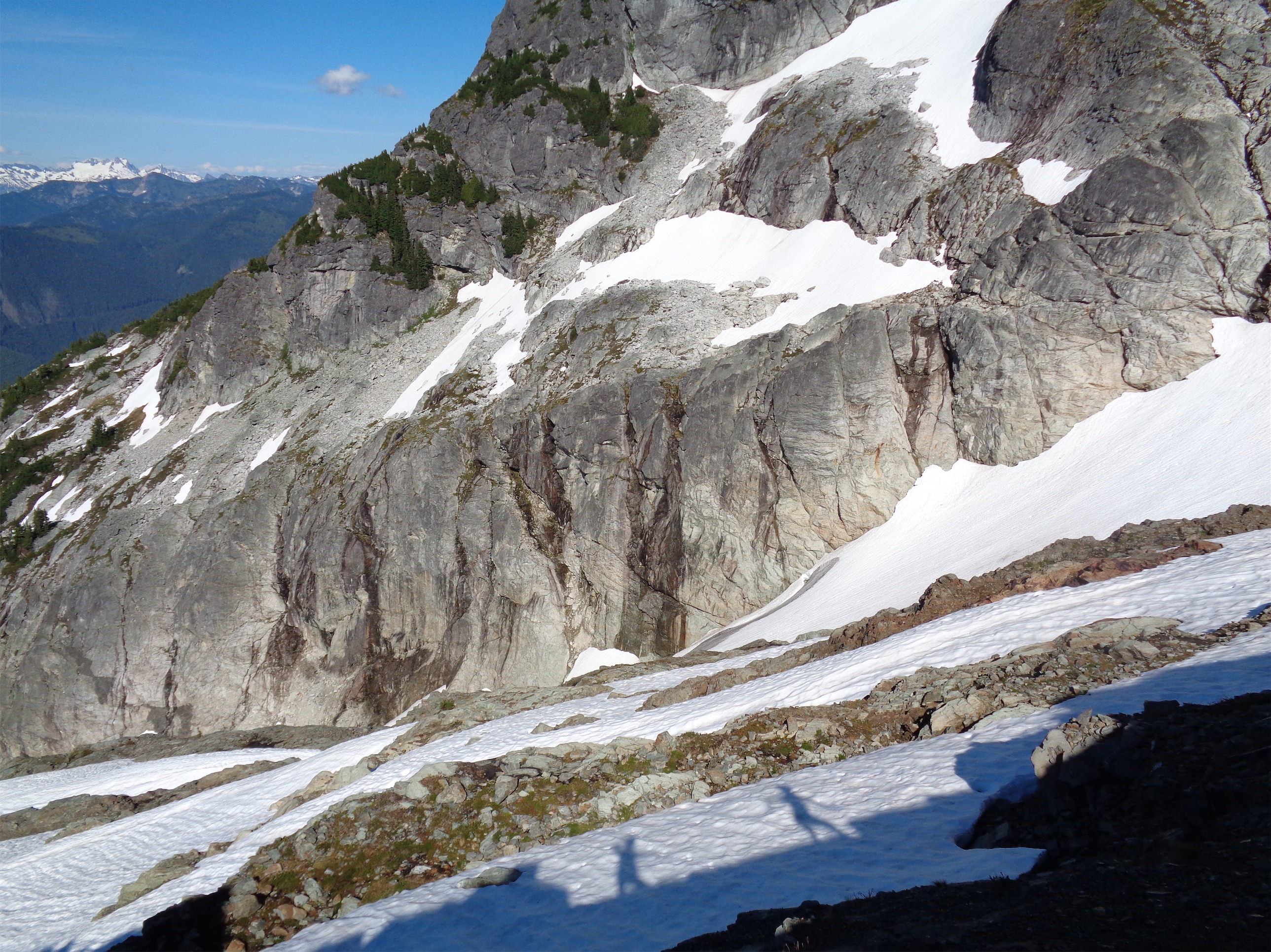
The ridge for the most part has an outcropping of rock on one side that you can hang on to if you don’t like exposure. And for the brief sections that didn’t have that railing of sorts, lowering your center of gravity helps. We didn’t crawl anything, but I watched Lee kind of squat-walk across a few very open areas while telling me how she didn’t love it, no she did not. There’s actually a small glacier as you reach the end of this ridge, called the Straight Glacier. It’s in the middle of a fault that runs through the entire mountain, which divides it into two very different types of rock. Greenschist, which from my understanding is terrible for rock climbing, and some type of quartz diorite which is much better. Just past the glacier (which you don’t cross, you just hike above it) on the nice rock is where the scramble starts.

One more pic of Lee along the ridge
The scramble looks intimidating (fun?) until you’re right below it and can see the route. There’s a dip in the rock that cuts diagonally along the face, making it a much easier grade than going straight up. And honestly, that’s the only section where you might need hands, depending on how comfortable you are with scrambles. The rest of it was more or less just an exposed, steep rocky hike. Every time Lee stopped I looked back and stared at her wondering if this was it, if this would be the point where she turned around. And she always joined me, after a few solid minutes of debate and some muttering about how unfortunately, she did not love this part. And that’s essentially how the next hour (which is how long the last mile took us) progressed. But that means more times for pictures and views and soaking in the very notion that we were in the middle of mountains climbing a small peak. On a Wednesday. While everyone else I knew sat in their offices.

Taken on the way down, but you get the idea

Fairy moss
After that first bit, which felt like the only real scramble, the trail alternates between rocky (maybe a light class 2 scramble) and a regular well traveled trail. Yes, the drop off is steep, as it was on the ridge, but it’s easy to follow the trail and if you’re worried, there are tons of handholds on the rocks on one side of the trail. Lee is a rock climber, and it was fascinating watching her find handholds when we were on the more exposed sections of the trail. We passed a few patches of snow, but the trail itself was snow free. The vegetation was much more scarce up there, but there were packs of wildflowers here and there, and a blooming moss we dubbed “fairy moss” because it looks like something out of a fairy tale. Hell, I didn’t even know moss bloomed. I learn something new on every hike.
(bad ass) stretch break
I do think one of my favorite moments of this hike was when I rounded a corned on the trail and waited for Lee. It had been a few minutes, so I shouted back to see how her battle with heights was going. “I’m fine!” she shouted back. Was she? Would this be the point where she stopped? I waited, in silence. And finally, the brim of her sun hat peeked slowly around the rock. Very, very slowly. Eventually the hat brim was joined by a hand, grasping for holds on my side of the boulder. And last but not least, the rest of Lee made it around the corner, only to see me giggling at the slow-mo cartoon scene unfolding in front of me. Too perfect.

Trail beyond the scramble
The trail gets more and more clear as you get to the top, and finally we made it to the final stretch of small boulders. There are many remnants of the old lookout, mostly metal cables lying all over the place. I hopped up on one of the rocks and almost fell over. Glacier Peak! I had completely forgotten that this peak leads you to a panorama where Glacier Peak takes up your entire field of vision. I turned back to Lee and told her not to fall over when she saw the view, to which she replied with a string of Bostonian vulgarity and “DON’T TELL ME THAT RIGHT NOW” as I chuckled (and felt a little guilty).

Made it!
Glacier Peak had far less snow on it than I thought. Probably because the last time I had seen it up close was weeks (months?) ago. Maybe this is just how it looks in summer with evening light on it, since it was about 6pm at this point. We naturally took a break here for snacks. I was in such a hurt to leave that all I had was cheese and bread I stole from my roommate (thanks Pattra, I took the multigrain bread that’s been sitting in the fridge since like February) and a honey stinger gel. But I mean that’s basically dinner (cheese sandwich) and dessert (honey with some B vitamins). Sweet. Crap, I’m hungry. You have to pay for the snacks on this plane, which is bullshit.

Lee doubled in my panorama
There’s another “glacier” I was curious about. There was definitely something that looked like a glacier on the north face of Pugh. I think the Straight Glacier is the only official one. The one on the north face was tiny, absolutely tiny, but it definitely had that look of old glacial ice peeking through snow. Maybe now that it’s so small, it doesn’t qualify anymore? We’re talking 200sq ft, if that. I wonder if it was larger decades ago.
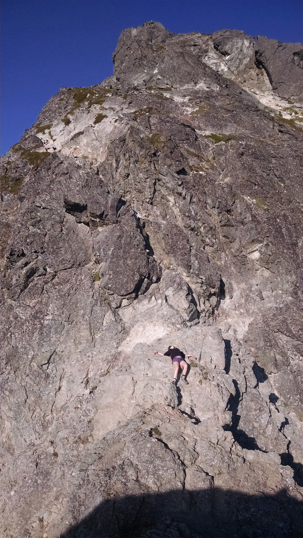
Lee’s relief after making it past the scramble. Lee: 1, Pugh: 0
While we were thrilled to make it to the top, the battle’s only half over at that point. Going up is optional, going down is mandatory. Lee admitted that a few of the times she nearly stopped were because she was thinking about how she’d have to get back down these sections too. Fortunately, the way down went more quickly and seemed much easier than the way up. And now that she was feeling a bit better (lots of scooting on her butt here) she asked me to see if I could get pictures of her looking bad ass. Challenge. Accepted.
It was basically an invitation for me to scramble off trail and see if I could set up in a spot where I could try to capture the steepness and exposure, which was much more difficult than expected, especially because I had to avoid putting myself into a position where I could fall, and a lot of the best angles were blocked by, well, rock. Steep rock that I can’t climb. But I got a few good ones. And my personal favorite, Lee lying with relief at the bottom of the scramble after coming back down. Lee 1, Pugh 0!
I was so excited that we had done it. It’s always very cool watching someone successfully push their limits. And it’s even better looking back on where you were a year ago. Lee mentioned that just a year ago, she’d never have been able to do anything like this, and here she was hiking along an open knife edge ridge. And for me, looking back on my notes beneath Pugh saying maybe bring company or wait until you’re more experienced, it’s funny how straightforward the hike was compared to much of what I’ve been doing. Could I have done solo it last fall? Yeah, I think so. Would I have been anxious and stressed the whole time? Definitely. Much better to wait until I had developed more confidence with scrambles, navigation, hiking pace, gear and supplies, etc. And I love being able to point out peaks around us, which Lee kindly tolerated for the entire hike. I couldn’t do that last fall!

Along the ridge on the way back, with Baker, White Chuck, Shuksan, and a chunk of the North Cascades
Back at the ridge, the going was quick. It’s so freaking gorgeous. We were back at Stujack pass pretty quickly (my phone died at one point so I have no Strava record) and missed seeing sunset there by maybe 15 or 20 minutes. We were too fast (ha! fast compared to the way up, at least). It set while we were in the trees heading back to Lake Metan, and we could see the brilliant pink and red and orange colors through the trees. I bet it was spectacular. But we were eager to get back to the car. I freak myself out on dark trails.
Shadows along the ridge
We actually made it back without headlamps, though we probably could have used them for the last 20 minutes or so. By the time we got back to the Mountain Loop Highway, it was dark. I texted Pattra and Lee called her boyfriend so people knew we were alive and not lost or injured in the woods, and didn’t make it back to Seattle until around 11:30, and I rinsed off in the shower (you’re welcome) and went straight to bed since I had to be at work at 8 the next morning. Worth it? Totally worth it. Pugh makes you feel like you’re legitimately climbing a mountain in the wilderness while staying pretty tame. No highways to listen to or ruin your views, some sketchy sections of trail, plenty of rocks to climb over, and some exposure to test your mental game. And Lee’s finally got her first scramble under her belt!

Go Lee! Congrats!
LikeLike
Thanks for this great report! I take my dog Trouper, an Australian Shepherd with me wherever it’s “legal” to do so but I’m wondering if you think this trail is safe for him. What do you think?
LikeLike
Here’s the disclaimer: dogs always surprise me with how good they are at hikes. But it sounds like most dogs turn around at the pass. If he’s pretty sure footed, I think he could handle the ridge. The first few steps of the scramble might be tricky for him to come back down, so that’s where I’d be careful! It looks more dramatic in the pictures than it actually is, but after hearing about the woman who got stuck with her dogs at Headlee Pass (they were too big for her to lift them to get them down over a few rocks) I’m overly cautious. Even if you just go to the ridge, the views are still phenomenal!
LikeLike
Thanks a lot! I got tied up with some significant family matters and didn’t see your reply until just now. I’m sorry I didn’t reply sooner.
LikeLike
The correct name for the “fairy moss” is moss campion. It’s not actually a moss; it’s a flowering plant, in the same plant family as the garden carnation, believe it or not. Real moss doesn’t get flowers.
Mount Pugh is one of my favorite trails though due to the difficulty and the distance getting to the trailhead I’ve only done it twice. The first time was magical as beyond the pass the trail always looked like it was about to end yet kept finding a way to go on despite the steep terrain.
LikeLike
Pingback: Spring Training | Have Tent, Will Travel
Pingback: Sloan Peak via Bedal Creek | Have Tent, Will Travel