
Rob and Simon at the beginning of the scramble
Edit: Happy one year anniversary to the blog! Woo! Here’s a link to my first ever post… it’s come a long way, as have my photography skills (or lack thereof) and tendency to keep talking.
- Distance: 24ish miles round trip (surprise! 10 mile approach!)
- Elevation gain: ~7000ish?
- Weather: high 20’s and snowing to 50’s and sunny. Yay, mountain weather!
- Commute from Seattle: Just over 3 hours
- Did I Trip: I fell on my ass twice and struggled like a beached whale to get over the final summit block if that counts
- GPX file here (summitpost also has one for just Golden Horn)
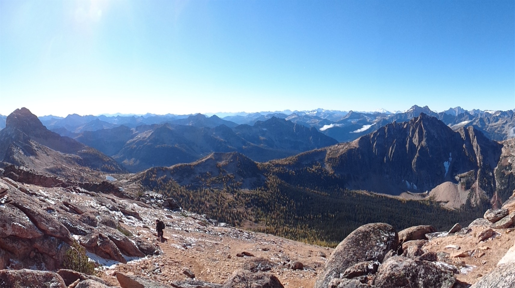
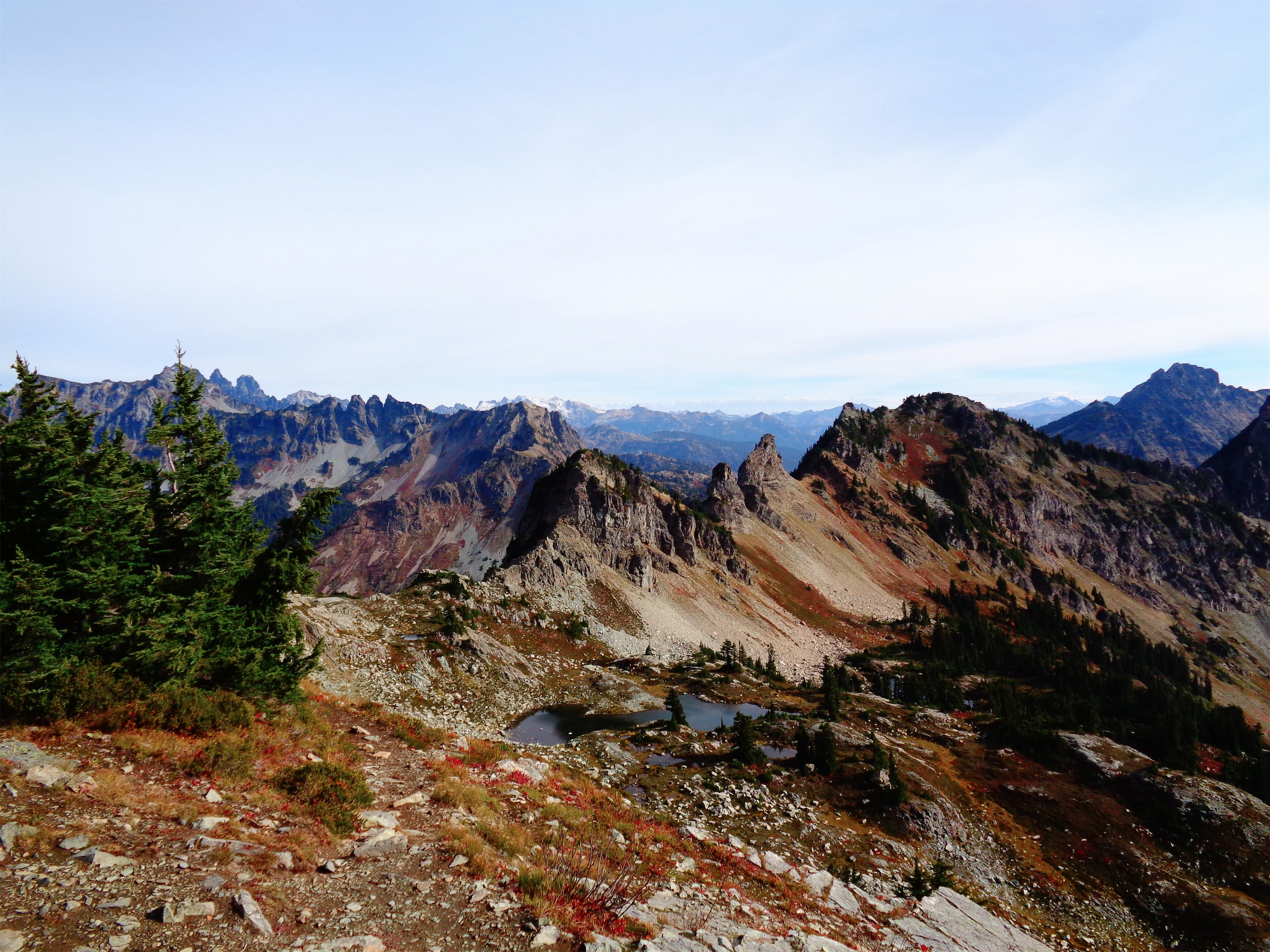
Awesome topography in every direction
So there was one potential issue with this trip from the beginning that I neglected to tell my teammates: I was sick. For those of you who don’t know me, I almost never get sick. So when I do, I’m a victim of the man cold. It’s all over, I must be dying, what do I do? Do I eat soup and wash my hands a lot? I have no idea. Actually, you know what might cure me? 48+ hours of physical exertion, little sleep, no showers, and sleeping (trying) in a germ cocoon. Yeah, that’ll do it.

Kacie in fall colors
I knew John and Rob from Rainier back in August, but had just met Kacie and Simon. Simon pulled up in a manual transmission off-roading jeep and immediately offered me hot chocolate, so he had to be cool. Kacie made herself crack up all alone by changing the color of her inflatable tent lamp, so she had passed the test too. After a soggy night that staunchly defied the “0% precipitation” forecast, we got started.
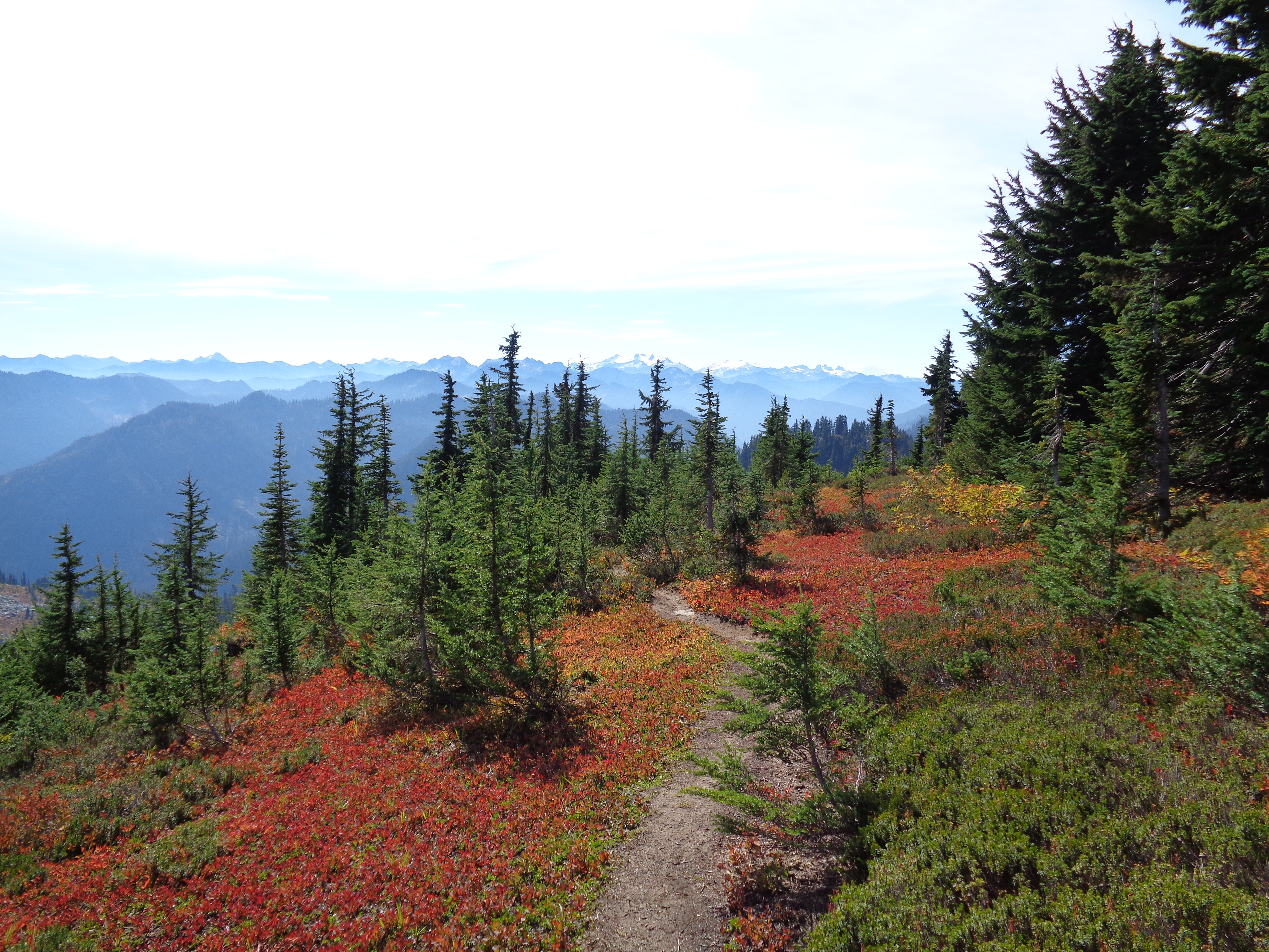
From the beginning, the hike was gorgeous, even in the fog. The approach is entirely along the PCT, meaning mellow, well groomed, soft flat trails. Almost no elevation gain. We made good time. I had been worried about keeping up due to my abject lack of energy, but I did okay. Green trees and dirt gave way to white granite and larches, and soon enough we were all in a constant state of wonder. Everywhere you turned was beauty, it didn’t matter where you looked.
A few miles into the trail, I turned around and saw Simon talking on a banana phone, and Kacie exclaimed “You have service up here!? Do you have A Tree&Tree?!” and in that moment, I knew we had an awesome group.

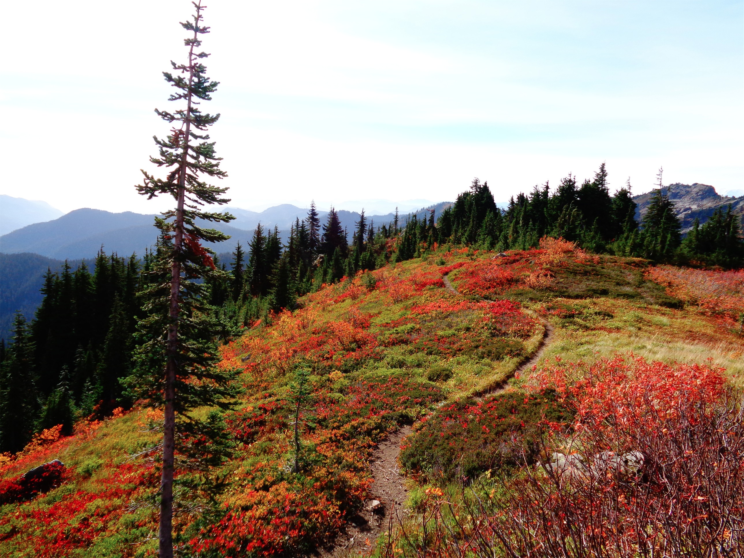
Flat, well groomed PCT
We continued along the PCT with occasional glimpses of Tower and Golden Horn through the clouds, but it didn’t seem like weather was clearing up. The trail is very straightforward, since you’re on one of the most well-maintained trails in the state. The offshoot for Snowy Lakes is maybe a quarter mile after you pass beneath Tower Mountain, directly across from an open field with a few campsites (and in our case, four far ass marmots lying on a rock). The trail turns from beautiful flat highway to steep and rocky, but not too steep and rocky. We were just spoiled by the PCT, and being back on a less maintained trail was hard.
Snowy Lakes were stunning as soon as we came around the corner. We set up camp on a ledge sheltered from the wind at the lower lake, in a nook away from the mobs of people (all relative, it was like 20 people total). Luckily, there were rocks. I had been worried about setting up my tent. I hadn’t camped on a non-glacier in… well… a long time. Did I need stakes? What if there weren’t rocks? How do you keep it from flying off in wind if you can’t deadman anything!? Oh wait, there won’t be as much wind. It was pretty out of place, but damn if that orange didn’t look great against the yellow larches and bright blue water.

It’s a little out of place

Looking back at Mt. Hardy
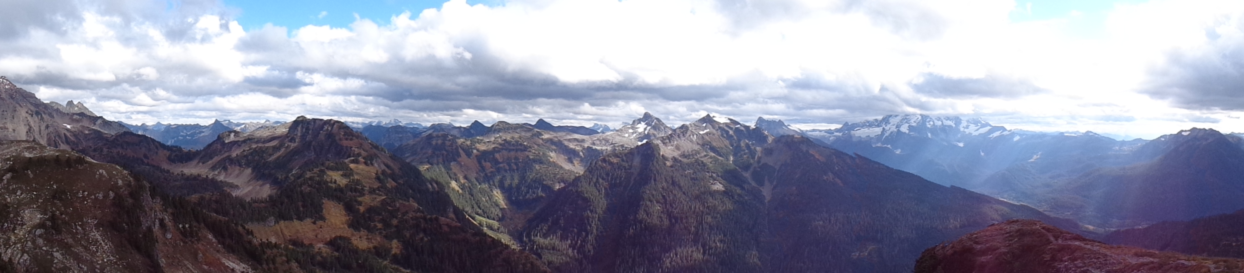
We waited a bit longer before aiming for Tower, hoping for weather to clear up, but since it wasn’t improving, we got moving. Onward! We went off trail a bit to get to the talus slope, and from there you just work your way to a cave that’s very visible from Snowy Lakes. Cross to the right in front of the cave, and you will find yourself in the main gully. As you gain elevation, views open up, and the ridgeline that grows into Hardy was a very neat topographical feature. If only it had been clearer.
We made it to the cave, and someone said “Rave cave! We even have hula hoops!” I laughed and said “really?!” before realizing what a gullible idiot I was. There are no hula hoops in the wild. Except five minutes later, crossing the cave entrance, there were hula hoops! Holy shit, I didn’t think you were serious! Okay, perk for the way back. We were watching clouds drop lower and lower on Tower as some low hanging dark clouds came towards us from Black Peak, so we wanted to move fast. I announced that I didn’t think we’d get dumped on, we just wouldn’t have views.

Snow in the gully (Photo credit: John)
Well, I’d be a shitty forecaster, because within 15 minutes, it was snowing. I’ll work on that. We made it to the gully (continue east past the cave and you’ll see the gully on your left) where we ran into a four person team that had turned around and had been waiting a long time for the other half of their group to get back. Much of the rock was frozen over, icicles included, not to mention the gully was a bowling alley of rocks to begin with. We let them pass us since they were turning around, and decided we’d still give it a shot. The left side is smoother with more exposure, the right side is more jagged with more prominent footholds and handholds, and that’s the way I’d suggest going.
It didn’t matter, we didn’t make it very far. We turned around maybe 200 vertical feet from the summit. It just wasn’t worth it. Cold fingers, low visibility, snow, rock fall, icicles, the potential for the entire fourth class scramble to be a sheet of ice on our way down… meh. We turned back, knocking down a microwave sized rock in the process. The other group was long gone, but it’s still a little unnerving.

Why would you stay at home when you can hula hoop in a cave on the side of a mountain?! (Photo credit: John)
Nearly back at the cave, Rob turned to me and just said “we should hula hoop!” I thought he was joking, but to hell with it, we got to the cave and picked up those damn hula hoops and went for it! There is nothing more hilarious than John and Rob hula hooping in a cave in the snow at 8,000ft. Well maybe the human ladder that happened 24 hours later, but we’ll get to that. We hula hooped, we broke into bouts of Beach Boys songs and dancing. I had Surfin Safari in my head (why? it’s the furthest topic from what we’re doing) and had shamelessly sung the opening verse a few times, which eventually triggered a spontaneous performance of Barbara Ann since we had a perfect division of bass voices and sopranos (if I try to be shrill enough). Barbara Ann became the song of the trip, much like Come and Get Your Love back on Eldoardo. It’s just hilarious and makes me smile every time. Anyway, imagine hiking up to a cave and there’s a bunch of people hula hooping in snow singing that. That would have happened, except that no one else was up there, because it was gross out.

Rave cave! (There was a bivvy spot in the back if you’re ever stuck)

Jesus brings out the sun back at the lakes
Energy renewed and spirits lifted, we set out back down the loose talus to head back to camp. Simon had turned around earlier, and we wondered what he might have in store for us. More hot chocolate? A fire? No, that’s a lot to ask. We stopped to take pictures of the snowy larches, lament how the weather wasn’t doing us any favors, and joke about how it was so foggy there WAS no peak to summit, I mean if you turn around there’s just nothing there! At Rob’s suggestion, we considered pathetically yelling “Simon!” in the fog close to camp, hoping he’d get the Touching the Void reference. But it wasn’t foggy enough, and we were so excited by what Simon had for us back at camp that we forgot anyway.
Not only was there hot chocolate, there was a fire! In the snow! Woo! We had our hot drinks and crowded around it warming up, until someone turned around and saw the sun breaking through the clouds across upper Snowy Lake. We dropped everything except cameras (and in Simon’s case, his precious fifth of vodka) and ran to the upper lake to take pictures. A group of unhappy looking campers was making dinner as we excitedly ran past to see the sun on the lake, and the next hour was spent running everywhere like overexcited chickens snapping pictures, talking to other pictures, doing karate, walking on water, skipping rocks (or trying to learn how, for me – “did you even have a childhood?!”) and enjoying the situation to its fullest.

Sun sneaking beneath the clouds

“I’m a blackbelt what’d you expect?”
We finally figured we had overstayed our welcome at the upper lake. We were loud, and I proclaimed it was time to go back to our corner. We invited everyone to come to our fire, where we had plenty of food and drinks. Alcoholic or just cozy, take your choice. No one took us up on our offer besides a camper across Lower Snowy Lake from us, who couldn’t resist the offer of fire and warm drinks and hilarious jokes. We crowded around it again as night fell, and thoroughly enjoyed our Backpacker’s Pantry meals, tabasco hot chocolate (sorry Kacie, I’m not sold on it), spiked hot chocolate, various kinda of tea, and finally, an apple crumble dessert. From Mountain House. Dehydrated. It was delicious, and would make a great breakfast too. Take note.
My body finally caught up to me, and I retired to my tent. My germ cocoon. Friday night I had felt iffy, Saturday night was doomsday. Doomsnight. I snuggled in my sleeping bag, freezing cold, and waited out the misery. Come on, body. Get over yourself, you have shit to do tomorrow. I finally gave up around 6am and left the tent to explore the outdoors since sleep was clearly a hopeless endeavor.

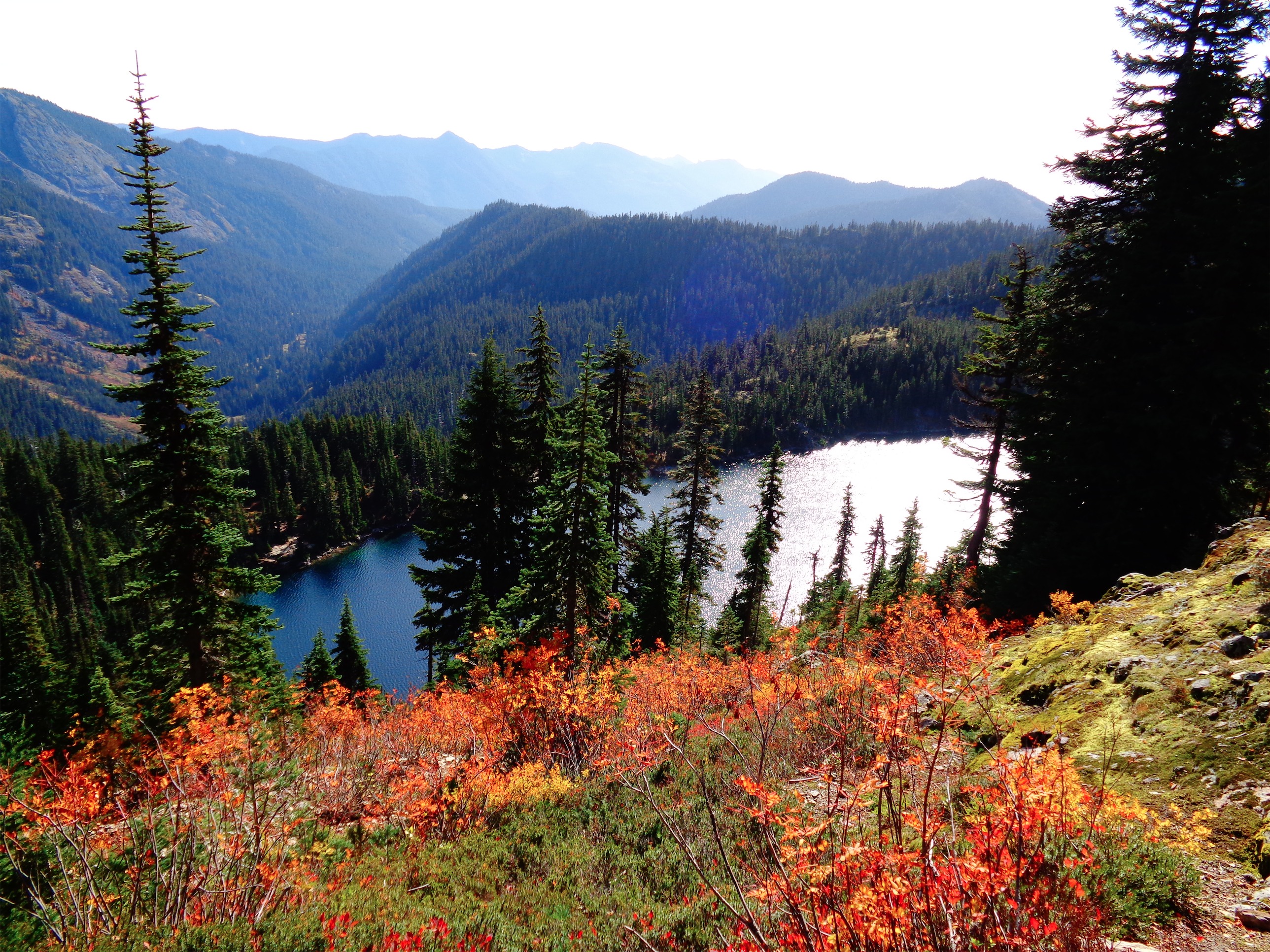
Golden Horn reflected in Lower Snowy Lake

Mt. Hardy reflected in Upper Snowy Lake
I got to watch sunrise light up Golden Horn, and snap pictures of reflections in the lakes. I hit up the lower ridgelines to look out over the clouds at the ridge across the valley. Eventually everyone else woke up and we made tea and hot chocolate. Guys, I’m used to being up and moving within an hour of waking up. Sitting around for three hours drove me insane. I don’t work well with casual starts, apparently.
We finally got moving a little after 9am. There was a group ahead of us on Golden Horn that I had run into before the rest of my team woke up, so I knew we’d have company. I was a little worried about keeping up with everyone given how I was feeling, but eh, I’d play it by ear. We were in such a beautiful place, it wouldn’t even matter if I missed out on the peaks.

Looking back at Tower over Snowy Lakes
The hike to Golden Horn is almost entirely line of sight – walk across scree fields until you’re nearly at the base of the summit block, and then do a little class three scrambling to wrap around to the southwest side of the peak. A short gully will bring you to the final few steps. Here, stay on the southwest side of the peak, don’t try to go for the north side. The other group had been staring at the northwest side for a long time, and was about to give up when we showed up and scouted out the southern side. We all joined up, and Joe offered to lead it.
He used two cams, 1 and .75 I think. There was a great horizontal crack in the second slab, and the second crack he utilized was between a flat boulder and the cube of granite that made up the final move to the summit. An elegant muscle up/shimmy combination, and he was on top! We let their team wrap up before sending John up to top rope our group.

Rob on the shimmy move
I couldn’t figure out what the hell was taking John so long to get a good anchor set up. He finally got it worked out, and I got Kacie roped up and ready to go on her first rock climb. Go big or go home! Rob was up next after Kacie tapped the summit, and he made the muscle up/shimmy move look easy. John lowered him, and it was my turn. Getting up to that top move was a breeze, so I figured it couldn’t be that bad. I hopped up, got my elbows over the edge, and immediately realized it wouldn’t be so easy. For anyone who knew me in high school and college, my eight-straight-pull-up days are long over, and it was a pitiful fall from glory. My shoulders and lats forgot how to exist. I told John to drop me back to the flat ledge. I was gonna give it one more try before admitting defeat. Come on body, one push, just one push. With a shot of luck and a bit of a jump, I managed to drag my ass over the edge, only slightly resembling a beached whale. Hell. Yes. (note: how are there no pics or videos of people getting stuck trying to get out of a pool?! That’s what it was like)

Kacie got a solid 10 pics of the struggle

Got there eventually! (Photo credit: John)
I snapped a few pictures, laughed at John’s anchor (which was amazing but impressively precarious to set up, which is why it had taken so long), and had him lower me back down. Naturally I had wanted to rappel, but he was reluctant, and I realized I was in no condition to argue given how shitty I was feeling, and probably not in the best state for any major decisions either. Great, I’ll downclimb.
We finally went to regroup with Simon, who had patiently waited at the notch while we figured out the technical pitch. There was a tricky ledge we had to get across. I scuttled down it just fine (I think my state of mind took away the “look what’s below you, or isn’t” fear) but Simon announced that the previous group had used him as a human ladder, and when Kacie wasn’t sure about getting across, he grabbed a rock at the end, hung his body along the ledge and said “Okay, go, climb me!”

Simon sacrifices his body for the greater good

Simon coming back down the scramble
I think I cried laughing. Kacie’s face says it all. John was up next, and finally we were all across the ridge. At one point, I think Rob had told Simon he didn’t have to wait for us, and Simon had said “No, you need me to get down!” We had no idea what that meant until the human ladder happened. Simon for MVP!
From there, we made quick work of the hike back to camp. Plunge-stepping down scree is much easier than hiking up it, and before I knew it we were back at camp. Which was great, because I was losing hearing in my right ear (it still hasn’t returned three days later) and was on my way towards becoming a very useless group member. We took a break by the lake while everyone packed up tents (I can pack up that tent in like 10 minutes now). We finally had the lakes to ourselves, since everyone else had left. I ate about 1500 calories in one sitting. A beef and cheese burrito, a full thing of maple butter, a bag of m&ms, a kind bar, the combos that had spilled all over the brain of my bag. “Cheese flavored filling,” not even cheese. Whatever, they’re delicious.

The way the light reflected off the lake was ridiculous. That’s Rob in the bottom left corner for scale
The hike back out was the perfect end to a trip. Sunny, smooth, greeting PCT through-hikers, golden hour, and (we had hoped) the lunar eclipse. Unfortunately, we didn’t catch a glimpse of the moon. We knew it was a supermoon, so when we saw tons of stars, we knew the moon had to be eclipsed. On the drive back, the moon was so bright it kept startling me when it flashed through the windows, and I stopped while crossing a bridge to get a good look.

Fall foliage at golden hour


 Views of Shuksan were beautiful, even if we couldn’t see the peak through the clouds. Fall foliage was still everywhere, despite it being late October, and we lucked out because apparently the end of the road is already closed because of snow. From the top you could see Mt. Baker as well, and I imagine the views are insane on a clear day. The trail was well maintained, no tricky crossings or anything like that, and not too steep until the very end. The first summit is a false summit, and you have to hike down a bit and along a ridge to get to the real summit, which unfortunately my friends weren’t too keen on pursuing. One was wearing a t shirt and jeans (I don’t know how he wasn’t freezing), and it was freezing cold at the top with wind around 30mph (gusts up to 40mph) according to a few trip reports. I had on four jackets, one of which was windproof, thank god. Next time, when I go on a clear day, we’ll be getting across to the real summit.
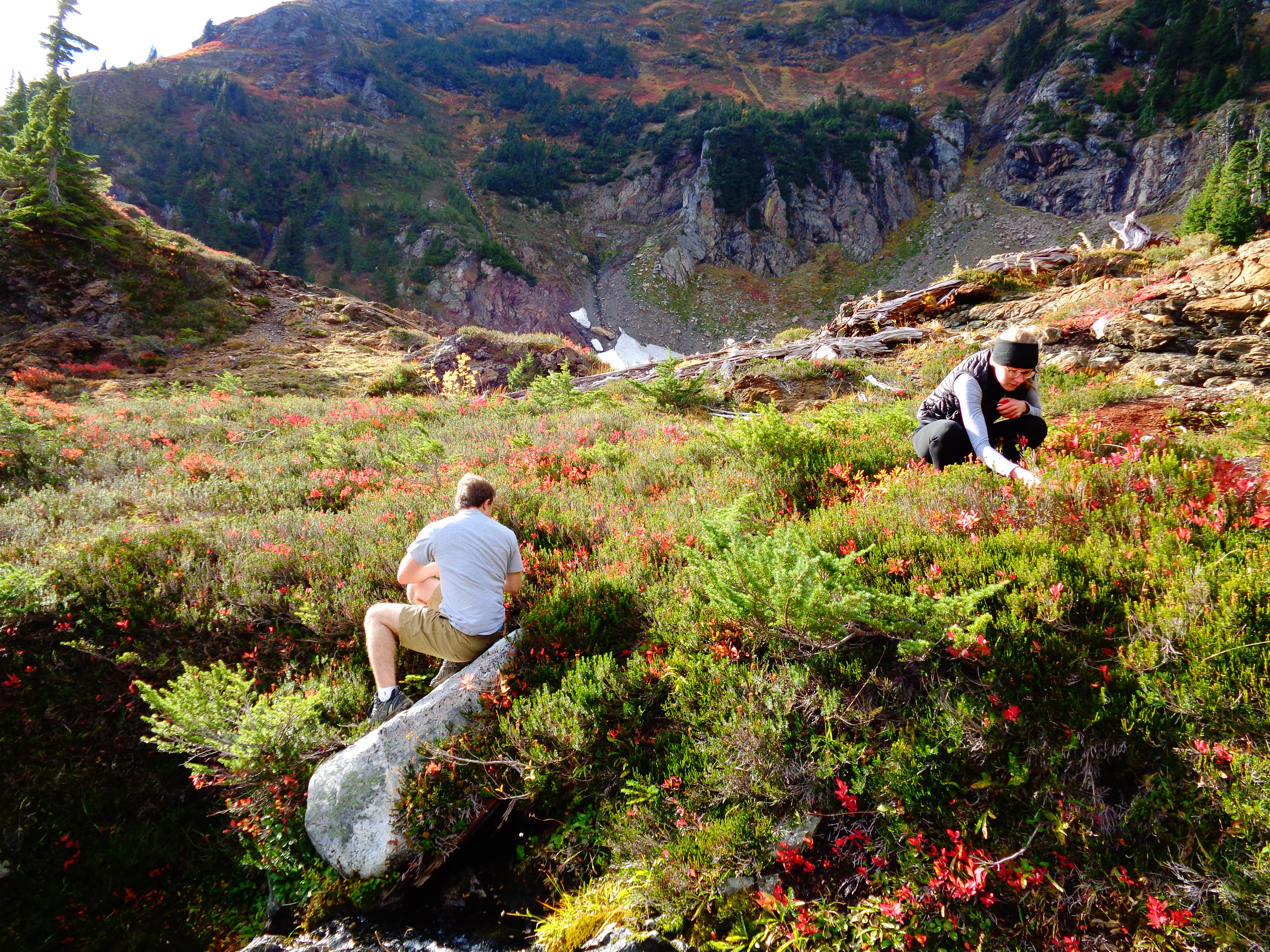


